
EDITORIAL · SITKUM CREEK FSR 0235 01
Another Rady? Selkirk District is tearing out Sitkum Creek FSR for the second time — on a road the public already paid to put back.
Sitkum Creek runs down off Mount Cornfield into the West Arm of Kootenay Lake, twenty kilometres north of Nelson. The Province designated it a community watershed in 1995, above a licensed waterworks serving thirty connections. Six active Kalesnikoff Lumber road permits cross that watershed today. One public forest service road crosses it, and that is the one the Selkirk Natural Resource District has posted for deactivation in June 2027 — 57% of the road, the whole upper half, every metre of the alpine access.The public already rebuilt this road once.
Six active Kalesnikoff Lumber road permit sections cross the designated Sitkum Community Watershed north of Nelson. One public forest service road crosses it. That road is the one the Selkirk Natural Resource District has posted for deactivation in June 2027, and it is the only road tenure in this watershed the Province holds in its own name.0301
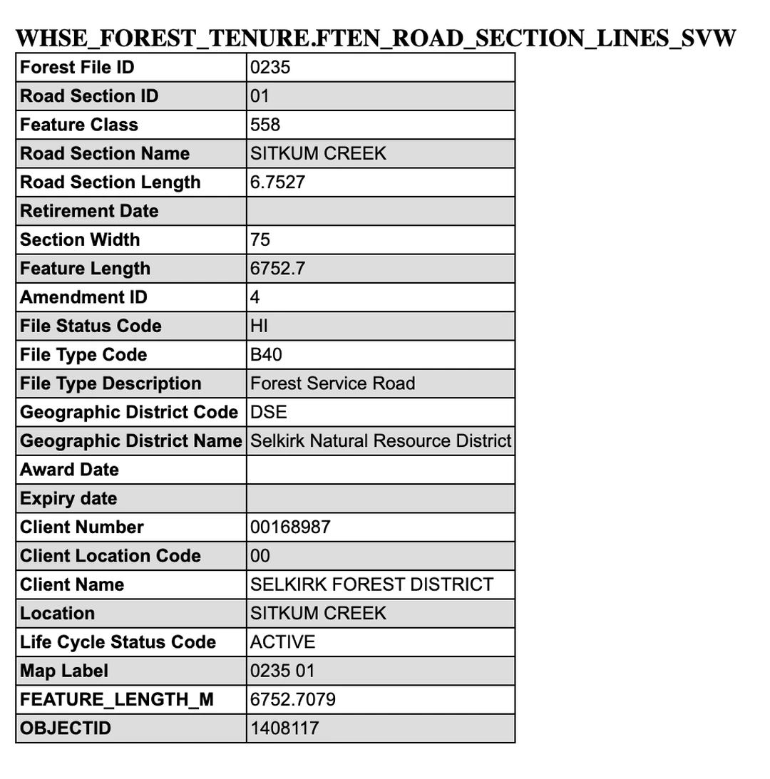
There is no licensee behind the decision to deactivate Sitkum Creek FSR. The Province’s tenure register records file 0235 as held by “SELKIRK FOREST DISTRICT”, client 00168987, on both of its sections. No forest company, no community forest and no commercial operator holds a road permit on it. The Ministry of Forests owns this road, maintains it, and has posted it for destruction.02
Sitkum Creek FSR, the road the Province owns, is the one being removed. The six Kalesnikoff Lumber permit sections through the same watershed are the roads that stay.
Section 01Fourteen road tenures cross the Sitkum community watershed. Six active Kalesnikoff Lumber permits stay; Sitkum Creek FSR, the road the Province owns, comes out.
Sitkum Creek falls off Mount Cornfield into the West Arm of Kootenay Lake, about twenty kilometres north of Nelson. The Province publishes the designated watershed boundary, the creek, the water intake and every road tenure that crosses any of it as map data anyone can download. Testing each road line against the boundary polygon returns fourteen tenure sections inside it.03
Here is that data drawn to scale: the boundary as the Province has it, Sitkum Creek and its tributaries, the intake at the bottom, the six Kalesnikoff Lumber road permit sections, and the public road — with the reach posted for deactivation picked out in orange. Read it for one thing: which lines are grey, and which line is orange.03
The Sitkum community watershed, the roads through it, and the reach being removed
The Sitkum watershed boundary, its roads, creek and intake, from the Province’s own spatial records. The designated watershed is 2,702.79 ha. Six of the eight Kalesnikoff Lumber road permit sections under R21133 cross it and are active. 79.8% of the public road lies inside it.03
The orange line is the part that goes. Everything grey stays, including all six industry road sections, which are active permits and are not posted for anything.03
Of the fourteen sections, six are dead permits held by companies that have left this drainage: four sections of Canadian Forest Products’ R09768, retired 5 October 2010; one of Westwood Fibre’s R15764, retired 3 November 2011; and one of Wildhorse Contracting’s R17038, retired 13 July 2017. Two are sections of file 0235, the forest service road. The remaining six are live, and they all belong to one company.0302
One of the two sections on Sitkum Creek FSR file 0235 is not the road anybody drives. Beside section 01 the register carries a second section of the same file whose section identifier is the word RETIRED, 7,490.1 metres long, lying wholly inside the designated watershed. No published code list explains what that identifier means on a live file, so the number is carried and not interpreted. The arithmetic around it is not in doubt: this one file already accounts for 7,490.1 metres of retired road inside this watershed, and the notice proposes to take 3,852.7 metres more.02
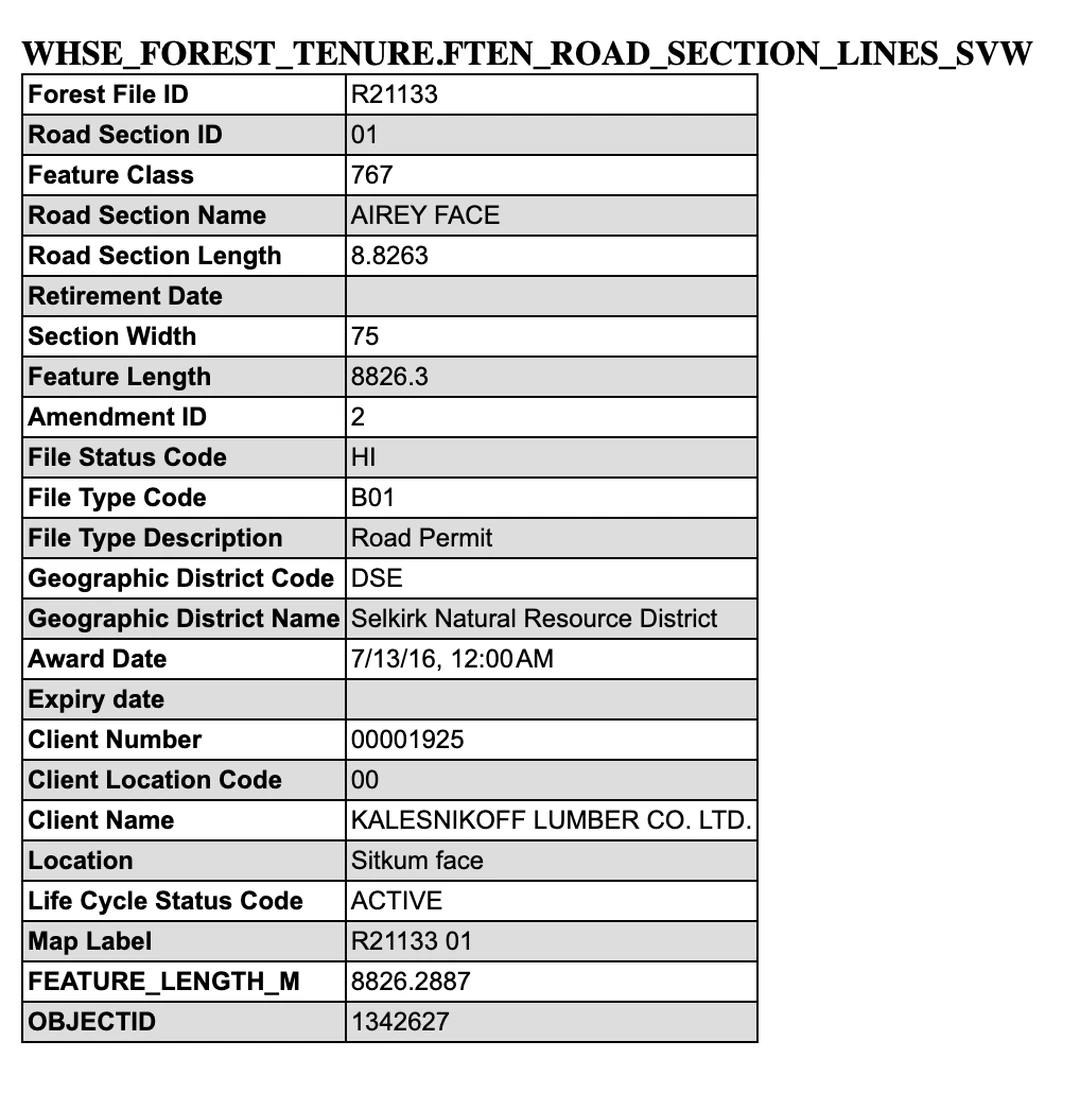
The six live sections are not a token presence. Under R21133 they run 8,826.3, 195.4, 501.9, 391.4, 381.0 and 677.1 metres, 10,973 metres of permitted road in total, of which the portion drawn on the map above is the part that falls inside the designated boundary. None of it carries an expiry date, none of it is posted, and the permit that authorises all six was awarded to one company in a single instrument.03
Start with the record for the public road, because it settles who is doing this to whom.
Now the record for the permit whose sections run through the same designated watershed and are not posted for anything.
Section 02The Province designated the Sitkum community watershed in 1995 to protect thirty connections, and has never written its water quality objectives
On 15 June 1995 the Province designated the Sitkum catchment a community watershed under the Forest Practices Code — 2,702.79 hectares above the intake of a licensed waterworks run by the Sitkum Creek Improvement District. A designation is not a gesture; it is a record with fields in it, and those fields record what the water system is afraid of and what has not been done about it.04
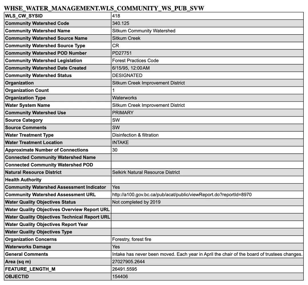
The intake sits at the bottom of the catchment, downstream of all of it. Every one of the thirteen points of diversion on this creek lies below the reach proposed for deactivation, and the designation is recorded against the Improvement District’s own point of diversion, PD27751. The register carries 25 current licences on Sitkum Creek, 18 of them current domestic licences held by private households.0504
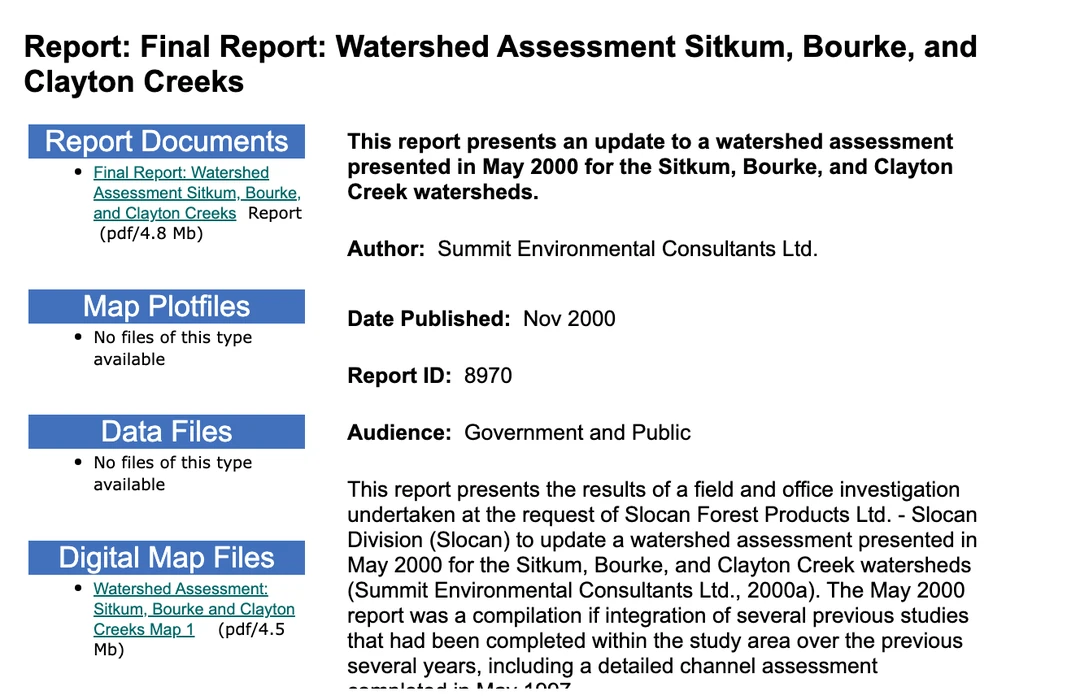
The record carries exactly one link to work that was actually done. It resolves to a report written twenty-six years ago, commissioned by a forest company.04
A designation is supposed to lead to objectives. Thirty-one years on, the field still reads Not completed by 2019, and the fields that would hold the objectives themselves are blank.04
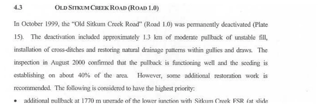
That catalogue entry is a stub. The Summit Environmental report behind it runs to seventy pages of field assessment, it was stamped in by the Ministry of Forests at Nelson in March 2002, and two of its pages are about Sitkum Creek FSR.27
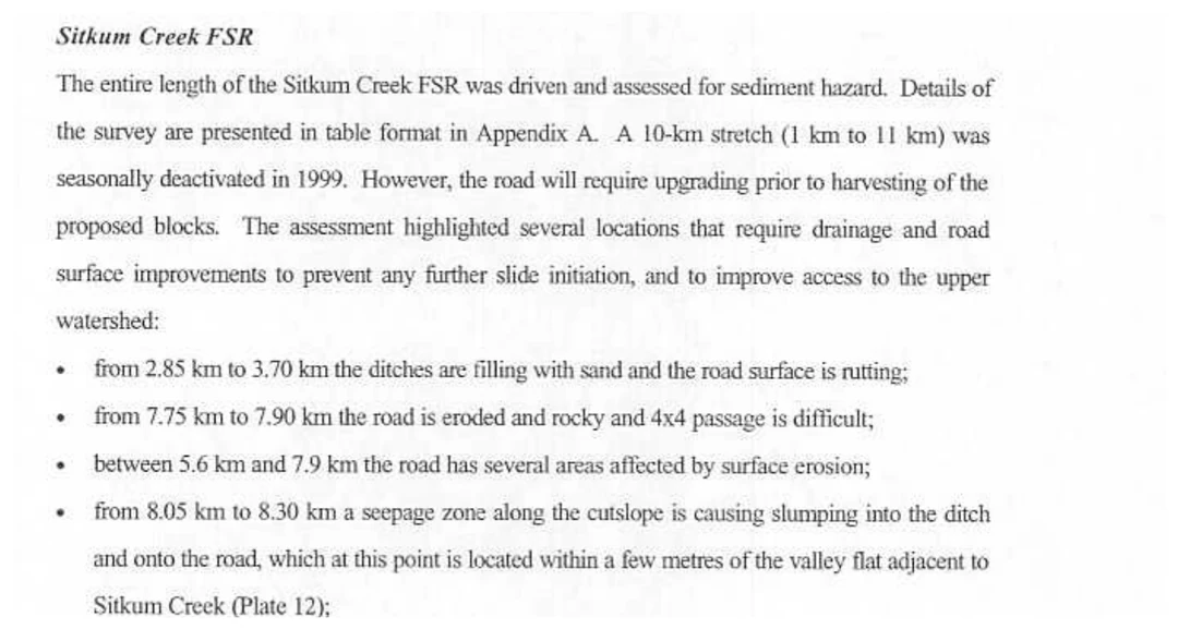
The same report records that this drainage has been here before.27
Put the whole thing on one line, with every year placed to scale. The bar across the top is the period in which the water quality objectives were not written, and it runs the full width of the chart because it is the full width of the designation.04
Thirty-one years of the Sitkum watershed designation with nothing behind it
The Sitkum community watershed, designated 15 June 1995, assessed 2000, water quality objectives recorded as “Not completed by 2019”, Sitkum Creek FSR posted for deactivation 6 July 2026.0401
The Province is proposing to destabilise 3,852.7 metres of Sitkum Creek FSR road prism above the waterworks intake it designated for protection in 1995 and has never written a water quality objective for.
Section 03Selkirk District’s notice takes 57% of Sitkum Creek FSR, and every metre of it above the halfway point
Deactivation is not closure, and the difference is the whole of what is at stake. Closure is a gate and a sign; the road survives it. Deactivation is earthwork. Section 82 of the regulation, headed Road deactivation, requires the person doing it to barricade the road surface width in a clearly visible manner to prevent access by motor vehicles, to pull out bridge and log culvert superstructures and stream pipe culverts, and to pull the substructures too where leaving them would do material harm. What is proposed here is not a restriction on driving up Sitkum Creek FSR. It is the removal of Sitkum Creek FSR.06
One clause of that section does the work everything else in this story turns on. The barricade must stop motor vehicles “other than all-terrain vehicles” — so a deactivated road, by default, still lets a quad through. That is why Heights FSR had to say the opposite out loud: on that road the terrain instabilities are such that there will be no ATV access. Sitkum, posted the same day by the same office, says nothing either way, which is why the question in the last section of this page is a real one and not a rhetorical one.0601
The notice covers “from 2.9km to 6.8km,” which sounds like a middle section. It is not. Section 01 of Sitkum Creek FSR is 6,752.7 metres long and ends at km 6.7527, so the posted reach starts at km 2.9 and runs to the end. It is the top half, and it carries all of the alpine access.02
Sitkum Creek FSR also climbs hard. It leaves the valley at 719 metres and finishes at 1,312 metres. Drawn to length against that climb, with the posted reach shaded, the proportion is not arguable.02
Sitkum Creek FSR, in profile
Sitkum Creek FSR section 01 length 6,752.7079 m. The posted reach runs station 2.9 to 6.7527 — 3,852.7 m, 57% of the road. The climb is 719 m to 1,312 m.02
The split is not one the district invented for this notice. The Province’s own segment layer already divides Sitkum Creek FSR at km 2.9: station 0 to 2.9 is one segment of 2,900 metres, station 2.9 to 6.7527 is the other, of 3,852.7 metres. The notice takes the second one whole.02
Section 04Selkirk District publishes prescriptions, maps and an FAQ for other roads. For Sitkum Creek FSR it has published fifty-one words.
The district’s road safety page is where a deactivation becomes public, and it is the whole of what has been published about this one. Six roads are listed under Road deactivations. What matters is not the prose in each entry but what hangs off it.01
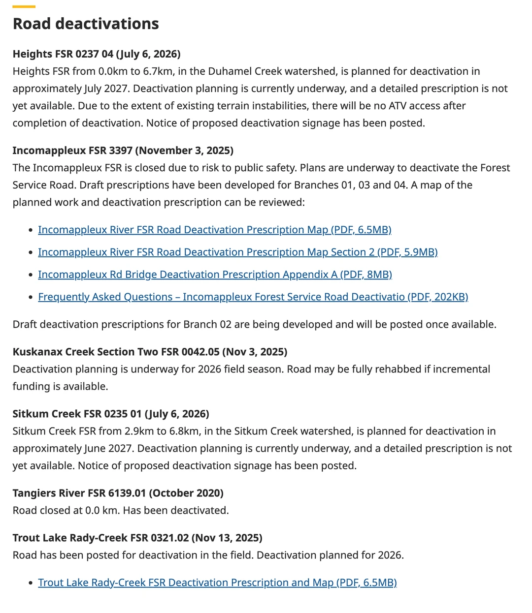
Three things sit inside those fifty-one words. The date is June 2027. There is no prescription — no engineering assessment, no map, no cost estimate, nothing a reader could argue with. And the district calls it “the Sitkum Creek watershed,” which is true but incomplete: the Province’s water register calls it a designated community watershed, and that designation is what attaches the only advance-notice duty in the regulation.0104
A written comment deadline is not a novelty in this office. It posted field signage and a written deadline for the Blazed and Jersey roads in July 2022, with comments due 31 January 2023. At Incomappleux it went further, and wrote down what it had done.17
At Sitkum there is a sign in the bush carrying a handwritten invitation to email the district office, and that invitation appears nowhere on the published page — not for Sitkum, not for any road under deactivation. The sign’s handwritten month also conflicts with the record, and the record governs: the page says approximately June 2027, and the July 2027 entry on it belongs to Heights FSR 0237 04 in Duhamel Creek.0122
Rady Creek is the exception, not Sitkum Creek. Selkirk District used a written comment deadline before Rady Creek and after it, and withheld that deadline from Rady Creek alone.
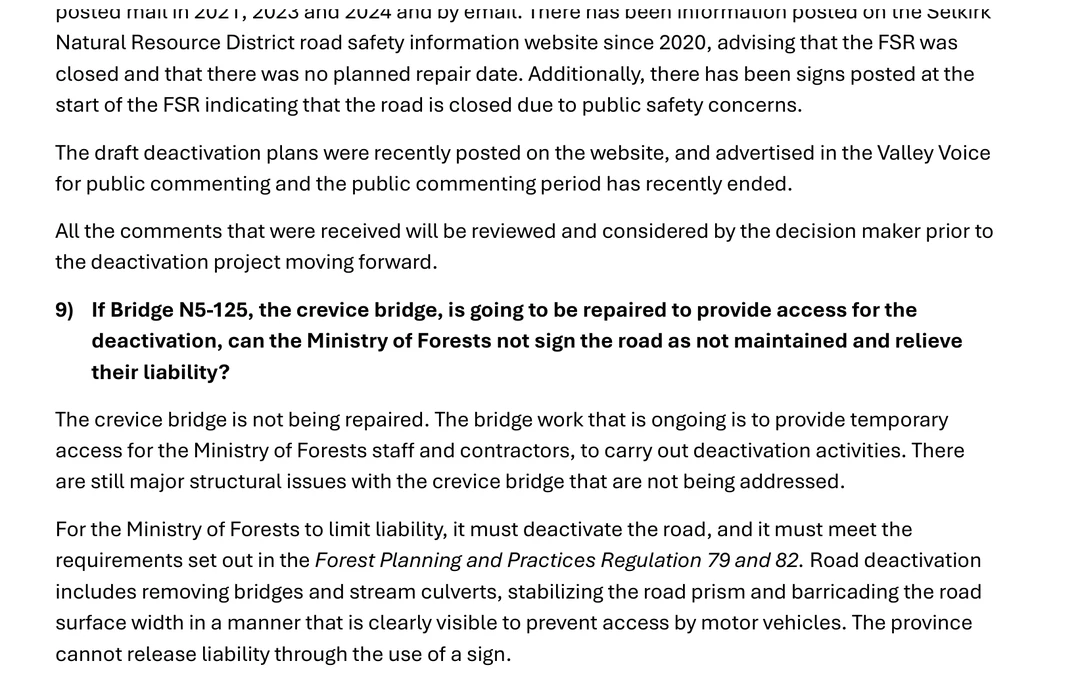
What a published prescription for one of this office’s deactivations actually contains, and what happened when one was finally prised out of it, is set out in the Rady Creek prescription. The relevant point here is narrower. At Incomappleux the document came first and the comment period followed it. At Sitkum the invitation exists and the document does not.17
Sitkum is a third case, and the strangest of the three. There is a comment invitation and there is no document to comment on. The district’s own model at Incomappleux is comment on a published prescription, advertised in the local paper. Here the prescription does not exist, by the district’s own words, and the deadline exists only on a sign at a trailhead.0117
Section 05The Forest Planning and Practices Regulation owes Sitkum Creek Improvement District forty-eight hours. Before Sitkum Creek FSR goes, it owes the public nothing.
Because Sitkum Creek is a designated community watershed, a notice duty does attach to this work. It is the only advance-notice duty attached to deactivation anywhere in British Columbia’s forest practices regulation, and it is one sentence long. The section printed immediately above it is the whole of what anyone else gets.06
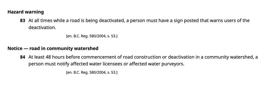
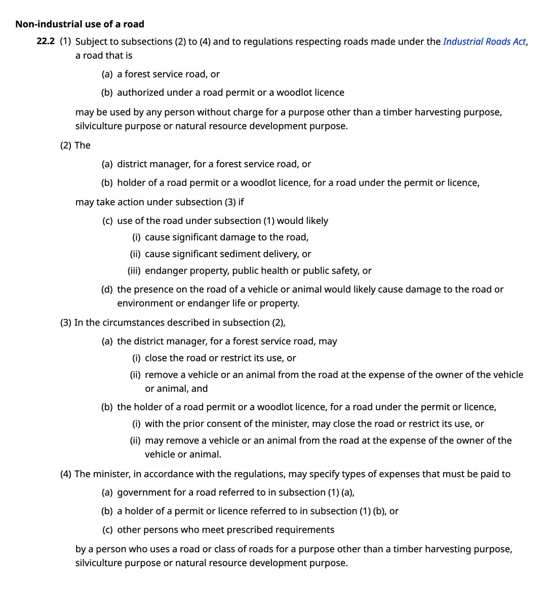
The power to shut Sitkum Creek FSR is drafted the same way. Section 22.2 of the Forest and Range Practices Act grants the public a forest service road and takes it away again inside the same section.07
Set that beside what the Forest and Range Practices Act requires before the minister may restrict a recreational use on Crown land. Section 58(3) provides that the minister “must post a notice of an order under subsection (1) in the area to which the order applies,” and section 58(4) makes it an offence to remove, alter, destroy or deface that notice.08
British Columbia makes it an offence to deface a notice restricting recreation. It requires no notice at all before removing Sitkum Creek FSR, which that recreation depends on.
One more distinction, because it cuts the Ministry of Forests’ way and then cuts back. Section 22.2 is the closure power, not the deactivation power. To close a forest service road or restrict its use under it, a district manager must first find that use of the road would likely cause significant damage to the road, or cause significant sediment delivery, or endanger property, public health or public safety — three doors, at least one of which has to be open, all three printed in Exhibit 10. Deactivation does not go through that section at all. It sits in sections 79 to 82 of the Forest Planning and Practices Regulation, which prescribe what must be done to the road and prescribe nothing whatever about who has to be told.0706
To stop you driving Sitkum Creek FSR, a district manager has to find one of three things. To take the road out, the Forest Planning and Practices Regulation asks for none of them.
Section 06Nothing forces Sitkum Creek FSR out. The Auditor General found no trigger, no timeline, and districts funded at a fifth of what they asked for.
A maintenance obligation runs until the road is deactivated or until “the minister notifies the person that the road should not be deactivated due to use or potential use of the road by others.” Under section 81, where a forest service road “is not being used by industrial users,” the standard drops to whatever avoids a material adverse effect on a forest resource. Sitkum Creek FSR can be left standing, lawfully, indefinitely — and the province’s own auditor put that in writing.0621
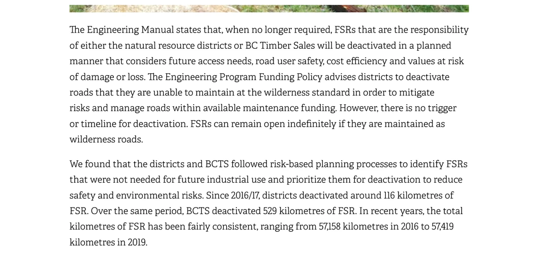
What does drive it is money, and the audit priced that on the next page but one.21
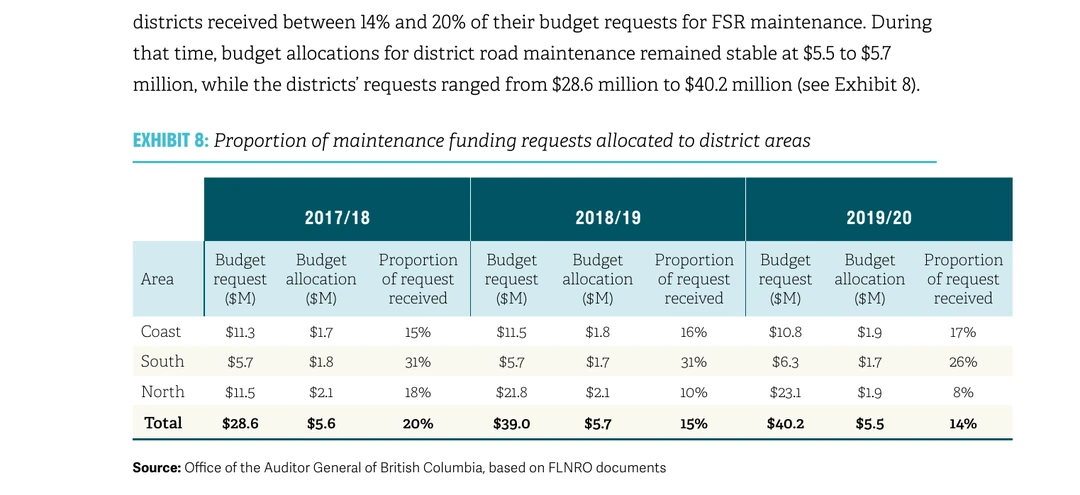
Hold the two numbers from Exhibit 11 against this road. Across the whole province, since 2016/17, the natural resource districts deactivated around 116 kilometres of forest service road between them, out of a network that has stayed near 57,000 kilometres throughout. The reach posted at Sitkum is 3.85 kilometres — about 3.3% of everything the districts have deactivated province-wide in a decade, in one drainage, above one designated community watershed. That percentage is arithmetic done here on the audit’s own figures and is labelled as such.2102
Section 07The Ministry of Forests pulled the Sitkum Creek bridge in 2014. Three Nelson Sno-Goers and $8,000 from Columbia Basin Trust put the access back in 2016.
In 2014 the Ministry of Forests deactivated the upper Sitkum Creek road and removed the bridge over the creek. Two years later a snowmobile club cut a new alignment and built a new crossing, with public grant money, to restore the access the Ministry had removed. Ten years after that, the same district office has posted the road beneath it. The dates, and the one hard dollar figure, in order.11
The Sitkum Creek crossing: removed, rebuilt, and posted again
The Ministry of Forests pulled the Sitkum Creek crossing in 2014; the replacement went in during September 2016; Sitkum Creek FSR beneath it was posted on 6 July 2026, for works in approximately June 2027. The markers are in order and not to scale — the gaps between them are drawn equal because this is a sequence of events rather than a measured span.1110
The clearest contemporaneous account of the 2014 removal was published a year before any of the rebuild happened, in a letter to the Nelson Star signed under its writer’s own name.09
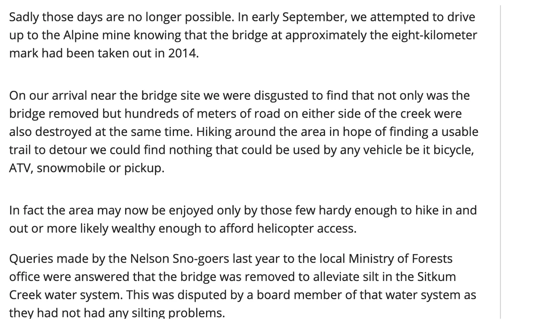
Take that rationale seriously, because the designation is real and silt is exactly what this watershed is designated to guard against. Then note who disputed it. A director of the very water system the Ministry of Forests invoked said publicly that it had no silting problem — the same Sitkum Creek Improvement District that section 84 now owes forty-eight hours of notice.0904
A year later, three members of the Nelson Sno-Goers put the access back. The labour and the materials are both on the record, and the materials are the part nobody expects.10
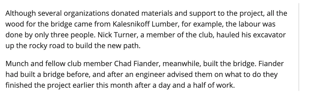
The funder is a Crown corporation the Province created, and its own record names the user groups it was paying to restore access for.11
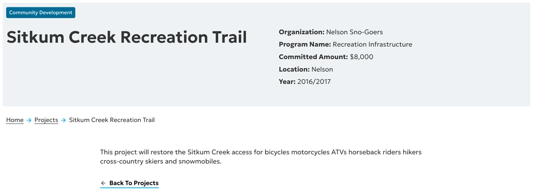
Be exact about what that bought, because the precise version is the stronger one. The Nelson Sno-Goers built a new alignment, not a repair — the previous route “wasn’t an option.” The bridge the Ministry of Forests pulled sat at roughly the eight-kilometre mark, above the posted reach. The notice mentions no bridge, and does not say one will be removed.091001
Deactivating km 2.9 to 6.8 severs Sitkum Creek FSR beneath the crossing the public paid to build in 2016. The Province does not have to remove that crossing to waste it.
There is a bleaker reading, and it comes from the mine owner’s own securities filing. Braveheart Resources’ technical report of 6 March 2018 runs 322 pages, names “the Sitkum Creek FSR and the Lemon Creek Road” in its accessibility section, and mentions neither a bridge nor the Sno-Goers anywhere in it. Among its risks it lists an “Outstanding lien on Sitkum Creek FSR with the Ministry of Forests, Lands and Natural Resource Operations.” By 2021 the company was still flying in.13
So 2016 restored recreational access — sled, ATV, bike, horse and foot, exactly as the Trust’s grant describes. It never restored road access. The public has paid to destroy Sitkum Creek FSR once and to reopen it once, and is being asked to pay to destroy it again.
The Province cannot settle the bridge question from its own files either. Its inventory of the structures it owns, load-rates and inspects returns nothing at all on Sitkum Creek FSR — neither the bridge it removed nor the crossing the public paid for.24
Section 08Sitkum Creek FSR was built for the Alpine Gold mine, and the fire that burned a third of the Sitkum watershed is not the one people remember
The people arguing for Sitkum Creek FSR take their history from a government database, not from folklore. The mine at the head of the creek has a provincial file, and the file is specific.12
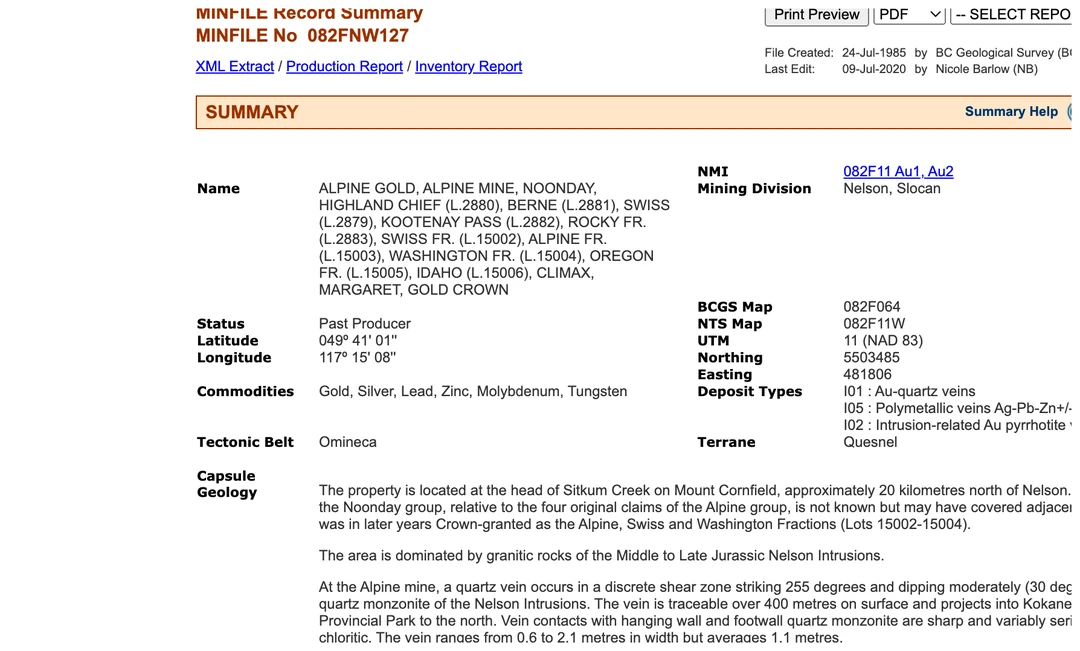
Fire is a real argument here, and it is not the fire everybody names. The 2015 Sitkum Creek fire is the one people remember: N70261, lightning-caused, ignited 30 June 2015, 777 hectares, visible from Nelson and Highway 3A. It is also the fire that largely missed the community watershed, burning under 5% of it. The fire that burned about 30% of this watershed was N70347, in 2007, at 1,075 hectares.15
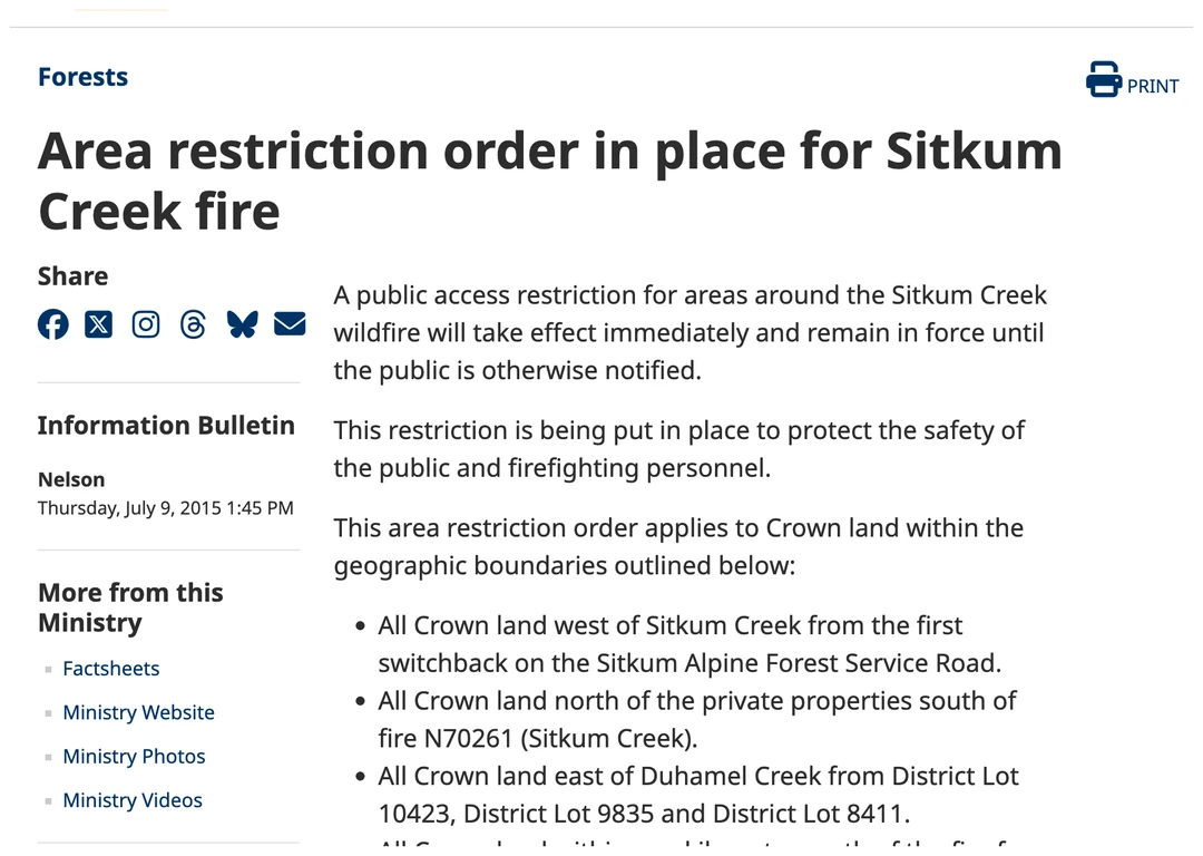
Sitkum Creek FSR’s documented link to fire is narrow and exact, and it is written into the 2015 fire closure order itself.14
Section 09The Sitkum watershed already beat a Kootenay Heli-Ski tenure in 2015, on the same water-supply argument
In March 2015 Kootenay Heli-Ski Inc. applied for a Crown land tenure in this drainage, thirty kilometres north of Nelson, bordering Kokanee Glacier Provincial Park, with more than seventy proposed helicopter landing sites. The public comment period drew 258 comments, all but three opposed. One of them made the argument on this page eleven years early.16
Public comment, reported in the Nelson Star · 4 August 2015
“This proposal makes no mention of the fact that Sitkum Creek Watershed is the water source for the Sitkum Creek Water Improvement District. Major disturbances in this watershed have compromised the ability to provide potable water to the community…”
RDCK Electoral Area F director Tom Newell opposed the application in writing. On 27 October 2015 the Ministry refused it, and Sharon Daily, section head for Kootenay Boundary land authorizations, gave the reasons on the record.16
Sharon Daily, section head, Kootenay Boundary region land authorizations · 27 October 2015
“The strong public opposition received in response to the proposal, impact to the ski-touring and snowmobiling tourism industry in the area and impact on environmental values are the factors taken into consideration for the disallowance of the application.”
In the Sitkum drainage, on this watershed, the Ministry has already accepted that public opposition plus snowmobiling tourism impact is sufficient reason to refuse. Tom Newell is still the Area F director, acclaimed on 17 October 2026. These two passages are quoted rather than imaged because the Nelson Star pages carrying them now redirect to the paper’s front page, which is recorded in the register with everything else that could not be retrieved.1623
Section 10Nobody with standing has been asked about the Sitkum deactivation, and no outlet has reported it
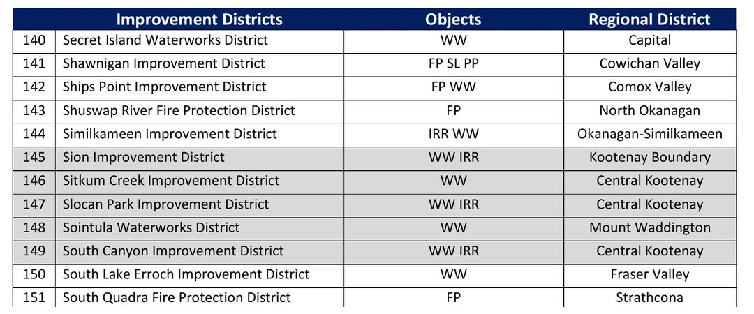
The Sitkum Creek Improvement District is entry #146 on the official provincial list of improvement districts. It is the statutory body the forty-eight-hour notice is owed to, it contradicted the Ministry’s stated rationale in 2015, and nothing in the record shows it has been asked about June 2027.18
The strongest current user stake here is not snowmobiling. Nelson Cycling Club Society holds recreation tenure REC6947, “Sitkum Creek Bike Trails,” and runs an annual “Sitkum DH” race with registration at the bottom of the course on the forest service road. Two further recreation tenures sit inside the watershed. None of the three appears on the Province’s public recreation index, where a search for “Sitkum” returns a different Sitkum, near Lumby.19
Four letters about this deactivation reached contact@backcountry.cx on 25 and 26 September 2026, addressed to the district office, the riding’s MLA and the BC Wildfire Service. Their bodies are near-identical: one account circulated by four residents, not four independent confirmations. Names and senders’ addresses are withheld. The recipient block is not, because it is entirely government.20
Addressed to
- FOR.SelkirkDistrictOffice@gov.bc.caSelkirk Natural Resource District — the office that posted the notice
- Brittny.Anderson.MLA@leg.bc.caMLA for the riding
- Two individual staff addressesMinistry of Forests — withheld
- FrontCounterBC.Nelson@gov.bc.caFrontCounter BC, Nelson
- BCWS.SEFCInfo@gov.bc.caBC Wildfire Service — Southeast Fire Centre
- BCWS.PWCO@gov.bc.caBC Wildfire Service
- Selkirk.Resources@gov.bc.caSelkirk Natural Resource District
Two of the eight are the wildfire service, so the residents writing are not treating this as a recreation question alone. Their asks: pause the deactivation, run a public consultation, release the engineering, environmental and cost analyses, consider reduced maintenance, seasonal access, gate management or partial deactivation, and recognise public access as a long-term value.
No news outlet has reported this deactivation. The region’s newspapers, the CBC, the provincial news service and the regional district’s own site return nothing on it, and the provincial open-records index contains no occurrence of “Sitkum.”25
The ask: publish the Sitkum Creek prescription, then take comments on it
Selkirk District says the Sitkum prescription does not exist yet. That is the opportunity, and it produces two requests that cost the Ministry of Forests nothing it has not already done at Incomappleux.
Publish the Sitkum prescription, then open a comment period on it. That is Selkirk District’s own model at Incomappleux, in Exhibit 08: a published draft prescription, a comment period advertised in the local paper, and comments considered by the decision maker. It ran that process eighteen months ago, from the same office, on the Incomappleux road.17
Give the Improvement District its notice, and give it properly. Section 84 owes that body forty-eight hours before a machine starts. Forty-eight hours is not consultation with a waterworks whose recorded concerns are forestry and fire, and for which no water quality objective has been completed in thirty-one years.0604
One more question can be answered in a sentence, because Heights answered it the same day: after deactivation, will there be ATV access on Sitkum Creek FSR? Heights says no. Sitkum says nothing, which means it is not decided.01
Six industry permits through this watershed are staying. The public’s road is the one coming out.
Share this story
Six images carrying the Sitkum Creek FSR story on their own — the deactivation notice, the 2016 rebuild and the community watershed. Made to be posted.


Slide 1 of 6
Suggested caption
Sitkum Creek runs down off Mount Cornfield into the West Arm of Kootenay Lake, twenty kilometres north of Nelson. The Selkirk Natural Resource District has posted 57% of Sitkum Creek FSR — the whole upper half, every metre of the alpine access — for deactivation in approximately June 2027.
Fourteen road tenure sections cross the designated Sitkum community watershed. Six are active Kalesnikoff Lumber road permit sections under R21133 and they stay. One is the public forest service road, and it is the one coming out — the only one of the fourteen the Province holds in its own name.
The public already rebuilt Sitkum Creek FSR once. The Ministry of Forests pulled the bridge in 2014. In September 2016 three members of the Nelson Sno-Goers cut a new alignment and built a new crossing, on an $8,000 committed grant from Columbia Basin Trust — a Crown corporation the Province created — with all the wood donated by Kalesnikoff Lumber.
The watershed was designated in 1995, above a licensed waterworks serving thirty connections. Its water quality objectives are recorded as “Not completed by 2019.” Thirty-one years on, they have never been completed.
Forest Planning and Practices Regulation section 84 owes 48 hours of notice to water licensees before deactivation in a community watershed. Before the public’s road is closed to the public, the law owes notice to nobody.
There is no prescription yet. That is the whole opportunity.
backcountry.cx/editorials/sitkum-creek-fsr/
#BCpoli #PublicLand #Kootenays #Nelson
Sources
- ↩↩↩↩↩↩↩↩↩↩Selkirk Natural Resource District road safety information, § Road deactivations. Fetched and read directly on 27 September 2026; the page footer reads “Last updated on September 18, 2026.” Source for the Sitkum entry quoted in Section 01, byte for byte: “Sitkum Creek FSR 0235 01 (July 6, 2026) — Sitkum Creek FSR from 2.9km to 6.8km, in the Sitkum Creek watershed, is planned for deactivation in approximately June 2027. Deactivation planning is currently underway, and a detailed prescription is not yet available. Notice of proposed deactivation signage has been posted.” Source also for the Heights entry bearing the same posting date: “Heights FSR 0237 04 (July 6, 2026) — Heights FSR from 0.0km to 6.7km, in the Duhamel Creek watershed, is planned for deactivation in approximately July 2027… Due to the extent of existing terrain instabilities, there will be no ATV access after completion of deactivation.” The July 2027 date on that page belongs to Heights, not to Sitkum, and this piece does not use it for Sitkum. The page publishes no comment deadline and no comment instruction for any road under deactivation, and no prescription, map, KMZ, engineering assessment or FAQ for Sitkum. The district contact published on the same page is FOR.SelkirkDistrictOffice@gov.bc.ca, 250-825-1100, 1907 Ridgewood Road, Nelson, B.C., V1L 6K1. The Sitkum entry is new in 2026: the same page archived on 10 March 2026 lists four deactivation entries and contains neither Sitkum nor Heights. https://www2.gov.bc.ca/gov/content/industry/natural-resource-use/resource-roads/local-road-safety-information/selkirk-natural-resource-district-road-safety-information
- ↩↩↩↩↩↩↩↩↩↩The road itself, from the Province’s forest tenure register. FTEN_ROAD_SECTION_LINES_SVW and FTEN_ROAD_SEGMENT_LINES_SVW, queried 27 September 2026. Section 0235 01 “SITKUM CREEK”: FEATURE_LENGTH_M 6,752.7079, file type B40 Forest Service Road, LIFE_CYCLE_STATUS_CODE ACTIVE, CLIENT_NAME “SELKIRK FOREST DISTRICT”, CLIENT_NUMBER 00168987, district DSE. The segment layer carries exactly two segments on that section: station 0 to 2.9, 2,900 m, responsibility code BC; and station 2.9 to 6.7527, 3,852.7 m, responsibility code OS. The published reach “2.9km to 6.8km” is exactly the second segment, and 6.8 is the Province’s own rounding of 6.7527. Coordinates (EPSG:4326): road start 49.605346, −117.178765; km 2.9 49.612009, −117.185349; section end 49.632899, −117.209067. Elevation 719 m at the start and 1,312 m at the end, a gain of 593 m; 5,392 of 6,753 m (79.8%) of the road lies inside the designated watershed. Two limits carried: only the start and end elevations are published, so the profile figure draws a straight line between them and says so; and no published code list decoding BC, OS or HI could be found, so they appear here as raw values and are given no meaning. One anomaly put on the record rather than used: the register carries a second section of file 0235 named RETIRED, 7,490.1462 m, whose own life-cycle status reads ACTIVE. A section named RETIRED and statused ACTIVE is contradictory on its face and is a question for the district, not a finding here. https://catalogue.data.gov.bc.ca/dataset/forest-tenure-road-section-lines
- ↩↩↩↩↩↩↩↩↩The map, and the road tenure inside the designated watershed. Every line in Figure 01 is plotted from the Province’s own spatial records, retrieved and drawn on 27 September 2026. The designated boundary is the single matching polygon in WLS_COMMUNITY_WS_PUB_SVW — 601 vertices, area 2,702.79 ha, matching the published area exactly. Roads are FTEN_ROAD_SEGMENT_LINES_SVW; the creek and its tributaries are the 34 Freshwater Atlas reaches of Sitkum Creek in watershed group KOTL; the intake is the point of diversion on the Improvement District’s waterworks licence. The count in the body is computed, not assumed: testing each road line against the boundary polygon, six of the eight Kalesnikoff Lumber road permit sections under R21133 intersect the designated watershed (sections 01, 02, 03, 04, 05 and 06; sections 07 and 08 fall outside it), and 79.8% of FSR 0235 01 lies inside — independently reproducing the figures carried in our research file. Drawing limits, stated: the projection is a local equirectangular one with longitudes scaled by the cosine of the mid-latitude, which is accurate at this scale but is not a survey; the boundary is simplified from 601 vertices to 110 for drawing, a tolerance under about fifteen metres and invisible at the size printed; Kalesnikoff lines are clipped to the map frame, so the figure shows the part of each permit that is in the watershed rather than its full run; and the other seven road tenure sections intersecting the watershed are not characterised here. Only the Airey Face section carries a published length, 8.8263 km. https://catalogue.data.gov.bc.ca/dataset/community-watersheds-current
- ↩↩↩↩↩↩↩↩↩↩↩The community watershed designation, field for field. WHSE_WATER_MANAGEMENT.WLS_COMMUNITY_WS_PUB_SVW, single matching row, queried 27 September 2026. CW_NAME Sitkum Community Watershed; CW_CODE 340.125; CW_STATUS DESIGNATED; CW_LEGISLATION Forest Practices Code; CW_DATE_CREATED 1995-06-15; POD_NUMBER PD27751; ORGANIZATION Sitkum Creek Improvement District, type Waterworks; CW_USE PRIMARY; CONNECTIONS_COUNT 30; treatment disinfection and filtration at the INTAKE; district Selkirk Natural Resource District; FEATURE_AREA_SQM 27,027,905.2644 (2,702.79 ha); ORGANIZATION_CONCERNS “Forestry, forest fire”; WATERWORKS_DAMAGE “Yes”; WATER_QLTY_OBJ_STATUS “Not completed by 2019”; GENERAL_COMMENTS “Intake has never been moved. Each year in April the chair of the board of trustees changes.” The intake sits at 49.6018263, −117.1791462. The assessment referenced by the record is “Final Report: Watershed Assessment Sitkum, Bourke, and Clayton Creeks,” November 2000, ACAT report 8970. Two limits carried: the designation instrument of 15 June 1995 has not been retrieved — the dataset is the evidence and the instrument is an outstanding records request; and the statement that every point of diversion lies below the posted reach is computed from the dataset coordinates along a creek the Province records as flowing south-east, not a hydrological assessment. Corroborated independently: Braveheart Resources’ 2018 technical report states that both Duhamel and Sitkum are designated community watersheds (source 13). https://catalogue.data.gov.bc.ca/dataset/community-watersheds-current
- ↩The water licences, and what is deliberately not printed. WLS_WATER_RIGHTS_LICENCES_SV, queried on source name 27 September 2026: 31 rows, 21 distinct licence numbers, 13 distinct points of diversion. Licence status: 25 Current, 5 Cancelled, 1 Abandoned. Purposes include 21 domestic (01A), of which 18 are current, 7 private irrigation, and 1 waterworks local provider. The institutional holders, and the only licensees named anywhere on this page: Sitkum Creek Improvement District (client 5085), licence C062543, waterworks local provider, 33,186.457 m³/year, Current, point of diversion PD27751, priority 1983-03-16; the same district’s domestic licence C065141, priority 1955-08-30; and the Ministry of Transportation and Infrastructure, licence 500542, 120 m³/year. The remaining rows contain roughly twenty private individuals with home addresses, and none of them is named, quoted, counted by name or linked here. That is a deliberate limit on this page, not an omission. https://catalogue.data.gov.bc.ca/dataset/water-rights-licences-public
- ↩↩↩↩↩↩↩Forest Planning and Practices Regulation, B.C. Reg. 14/2004 — read from the BC Laws consolidation on 27 September 2026 and quoted verbatim. s. 84, “Notice — road in community watershed”: “At least 48 hours before commencement of road construction or deactivation in a community watershed, a person must notify affected water licensees or affected water purveyors.” That is the entire section. It is the only advance-notice duty attached to deactivation anywhere in the regulation — s. 83 requires a hazard sign only “at all times while a road is being deactivated,” and s. 85’s notification to the minister covers timber harvesting and road construction, not deactivation. s. 79(3): “the government must maintain a forest service road, including bridges, culverts, fords and other structures associated with the road, until the road is deactivated” — so deactivation is the event that ends the duty. s. 79(2)(b): an obligation runs until “the minister notifies the person that the road should not be deactivated due to use or potential use of the road by others.” Honest caveat on that lever: s. 79(2) addresses a person authorised in respect of a road while s. 79(3) is the government’s own duty, so whether the minister may direct in the same terms on a forest service road is a question for the district and is not asserted here. s. 81, wilderness roads: where a forest service road “is not being used by industrial users,” s. 79(6)(a) and (b) apply “only to the extent necessary to ensure there is no material adverse effect on a forest resource” and s. 79(6)(c) does not apply. s. 82(1): a person who deactivates must “barricade the road surface width in a clearly visible manner to prevent access by motor vehicles, other than all-terrain vehicles,” remove bridge and log culvert superstructures and stream pipe culverts, remove substructures where failure would have a material adverse effect downstream, and stabilise the road prism where needed against the subjects listed in FRPA s. 149(1) — which is where water quality sits. Note the statutory carve-out: the barricade must let all-terrain vehicles through, so an end to ATV access is a consequence of pulling crossings and destabilising prism, not a rule the regulation imposes. This piece does not allege a breach of s. 84; the works have not begun and the duty has not yet been triggered. https://www.bclaws.gov.bc.ca/civix/document/id/complete/statreg/14_2004
- ↩↩↩Forest and Range Practices Act, SBC 2002 c. 69, s. 22.2 — read from the BC Laws consolidation on 27 September 2026. Subsection (1) provides that a forest service road “may be used by any person without charge for a purpose other than a timber harvesting purpose, silviculture purpose or natural resource development purpose.” Subsection (2) permits the district manager to act under subsection (3) where “use of the road under subsection (1)” would likely cause significant damage to the road, cause significant sediment delivery, or endanger property, public health or public safety. Subsection (3)(a)(i) permits the district manager to “close the road or restrict its use.” Nothing on the face of the section requires an application, a notice, a comment period, written reasons or an appeal. One precision held to: s. 22.2 closes or restricts use; it is a traffic instrument rather than a demolition instrument, and destruction runs through the Forest Planning and Practices Regulation and the Forest Act instead (source 6). Also read in full and carrying no deactivation provision at all: the Forest Service Road Use Regulation, B.C. Reg. 70/2004. Fuller treatment in The law everyone forgot. https://www.bclaws.gov.bc.ca/civix/document/id/complete/statreg/02069_01
- ↩Forest and Range Practices Act s. 58 — the notice the Province does owe, and what it is for. Read from the BC Laws consolidation on 27 September 2026. Section 58 is headed “Protection of recreation and range resources on Crown land.” Subsection (1)(b) lets the minister by order restrict or prohibit “a recreational use anywhere on Crown land, except a use that is specifically permitted under another enactment.” Subsection (3), verbatim: “The minister must post a notice of an order under subsection (1) in the area to which the order applies.” Subsection (4), verbatim: “Without lawful authority, a person must not remove, alter, destroy or deface a notice posted under subsection (3).” Recorded beside it, because it makes the same point on the process side: Forest Recreation Regulation, B.C. Reg. 16/2004, s. 2(1) requires that before making an order under s. 58(1) the minister “must publish in a newspaper” a notice stating the restriction, the area, the effective date, the duration and “the period during which, and the address to which, comments may be sent,” subject to an escape at s. 2(3). The comparison drawn in the body is between notice duties, not between penalties: s. 58 concerns restricting a use, while deactivation removes the road, and British Columbia attaches a mandatory posted notice to the first and none to the second. https://www.bclaws.gov.bc.ca/civix/document/id/complete/statreg/02069_01
- ↩↩↩↩↩Paul Moreau, “LETTER: Reopen Sitkum Creek Forest Service Road,” Nelson Star, 18 September 2015, 4:00 pm. Source for “the bridge at approximately the eight-kilometer mark had been taken out in 2014”; for “not only was the bridge removed but hundreds of meters of road on either side of the creek were also destroyed at the same time”; and for the Ministry’s stated rationale as reported to the club — “the bridge was removed to alleviate silt in the Sitkum Creek water system. This was disputed by a board member of that water system as they had not had any silting problems.” Why this is the source used rather than the letter campaign of 2026: it is dated, published, attributable to a named author, and it pre-dates the 2016 rebuild, which means the grievance is documented before the volunteers acted. Attribute the silt rationale exactly as it stands: this is Moreau reporting what the Ministry told the Nelson Sno-Goers in 2014, not a Ministry document. The rationale is also not baseless — the community watershed designation is real (source 4) — even though a director of the water system disputed the silting at the time. The same letter records that the road “only received maintenance when there was active logging in the area or a few years ago when it was instrumental in fighting the Sitkum Creek fire,” and carries the figure 11,457 troy ounces of gold, which matches MINFILE exactly (source 12). The indexed opinion slug now returns 404; the dated permalink is live. https://nelsonstar.com/2015/09/18/letter-reopen-sitkum-creek-forest-service-road/
- ↩↩↩↩↩↩Tyler Harper, “Bridge to the bush: Snowmobiler restores beloved trail,” Nelson Star, 20 September 2016, 5:00 pm. Source for the 2014–2016 sequence — “After the first fire, the Ministry of Forests, Lands and Natural Resources moved in to log the area. When that was done, the road was deactivated and a rotting bridge over the creek was removed” — and for the rebuild: “Munch and fellow club member Chad Fiander, meanwhile, built the bridge. Fiander had built a bridge before, and after an engineer advised them on what to do they finished the project earlier this month after a day and a half of work.” Source for the new alignment: “He applied for approval with the ministry in March to excavate a new road as well as build a bridge over the creek. The previous route, only visible now if someone is looking for it, wasn’t an option.” Source for the ~$12,000 figure, which is Greg Munch’s forward-looking estimate in September 2016 and is used in those terms only: “Munch said the total cost of the project will likely end up around $12,000 once a sign informing the bridge’s weight limit is installed.” Source for the grants — “Munch secured grants from the Regional District of Central Kootenay and the Columbia Basin Trust” — and for the single named donor: “Although several organizations donated materials and support to the project, all the wood for the bridge came from Kalesnikoff Lumber, for example, the labour was done by only three people.” Nick Turner hauled the excavator. Three corrections this source forces, all applied on this page: the bridge is described in the source as “more function than form,” so it is not called major; exactly one donor is named, so “several corporate donors” is not written; and the article credits approval to the ministry with money from RDCK and the Trust, so no role for Recreation Sites and Trails BC is claimed — a claim in circulation that this page does not repeat, and which a search of the RSTBC inventory does not support. The RDCK grant amount is not published here: it could not be verified to a figure, and no arithmetic is performed on the $12,000 estimate. https://nelsonstar.com/2016/09/20/bridge-to-the-bush-snowmobiler-restores-beloved-trail/
- ↩↩↩↩Columbia Basin Trust, funded-projects database — “Sitkum Creek Recreation Trail.” Organisation Nelson Sno-Goers; programme Recreation Infrastructure; committed amount $8,000; year 2016/2017; location Nelson. Project description, verbatim: “This project will restore the Sitkum Creek access for bicycles motorcycles ATVs horseback riders hikers cross-country skiers and snowmobiles.” The figure is used only as the Trust words it — a committed amount, not money spent and not the cost of the project. Columbia Basin Trust is a Crown corporation created by the Province, which is why this citation matters: the funder of the restoration is the same Crown whose district office has now posted the road beneath it. https://ourtrust.org/project/sitkum-creek-recreation-trail/
- ↩↩MINFILE 082FNW127 — read directly on 27 September 2026. File created 24 July 1985, last edited 9 July 2020. Primary name ALPINE GOLD; ALPINE MINE is a registered second official name, along with NOONDAY, HIGHLAND CHIEF and others. Status Past Producer; mining divisions Nelson and Slocan; commodities gold, silver, lead, zinc, molybdenum, tungsten. Verbatim: “The property is located at the head of Sitkum Creek on Mount Cornfield, approximately 20 kilometres north of Nelson”; “The Alpine Syndicate acquired the property in about 1936 and built a road to the property”; and “Intermittent production from 1915 to 1988 totalled 16,810 tonnes containing 222,044 grams of silver, 356,360 grams of gold, 49,329 kilograms of lead and 17,167 kilograms of zinc.” 356,360 g is 11,457 troy ounces, the figure in Moreau’s 2015 letter (source 9) — arithmetic on the Province’s own number. Point-in-polygon confirms the site sits inside the designated watershed (source 3). What the record documents, against what is sometimes said: the Basin, Meadow and adjacent claims were acquired “for a millsite,” and “A 50 ton-per-day mill was put into operation in December 1939 and operated intermittently until 1948.” What this record documents is a millsite. It documents no tramway and no townsite, and neither appears anywhere in the body of this piece. The 1936 road date is preferred over the 1934 date given in a 2016 newspaper account because MINFILE is the primary record and it agrees with Moreau. https://minfile.gov.bc.ca/Summary.aspx?minfilno=082FNW127
- ↩Braveheart Resources Inc., NI 43-101 Technical Report for the Alpine Property, 6 March 2018, 322 pp. Accessibility section, verbatim: “Access to the Property is gained via a network of Forest Service Roads (FSR) and un-named trails including the Sitkum Creek FSR and the Lemon Creek Road.” In 322 pages there is no mention of a bridge and no mention of the Nelson Sno-Goers — a qualified person writing a formal accessibility assessment eighteen months after the volunteer crossing went in did not record it as part of the access picture. Risk list, verbatim: “Outstanding lien on Sitkum Creek FSR with the Ministry of Forests, Lands and Natural Resource Operations.” What that lien secures is not established and is an open records question; it is reported here as disclosed and nothing is inferred from it. The same report is the independent corroboration that both Duhamel and Sitkum are designated community watersheds under FRPA. Braveheart’s press release of 6 May 2021 records that the route selected “will utilize existing forestry service access on Aerie Face and require new construction to the existing Sitkum Forest Service Road,” with a budgetary estimate of $350,000 to build it, and that the option agreement required expenditures of up to $700,000 to permit and construct an upgraded road to the mine site by December 2022. https://canadiancriticalmineralsinc.com/site/assets/files/2250/technical_report_for_the_alpine_property.pdf
- ↩↩“Area restriction order in place for Sitkum Creek fire,” Information Bulletin, Nelson, Thursday 9 July 2015, 1:45 PM — release 2015FLNR0175-001057, fetched and read directly on 27 September 2026. The order applies “immediately” and remains in force “until the public is otherwise notified,” to protect the safety of the public and firefighting personnel. Its boundary, verbatim and in full: “All Crown land west of Sitkum Creek from the first switchback on the Sitkum Alpine Forest Service Road. All Crown land north of the private properties south of fire N70261 (Sitkum Creek). All Crown land east of Duhamel Creek from District Lot 10423, District Lot 9835 and District Lot 8411. All Crown land within one kilometre north of the fire from Sitkum Creek west and over the height of land to Duhamel Creek.” The road is the legal reference line for the closure boundary and nothing more. No source describes it as a fireguard, a control line or a suppression access route, and this page does not describe it as any of those. Note a third official name variant recorded here: “Sitkum Alpine Forest Service Road.” The same release records that the regional district issued an evacuation alert and that the fire was “highly visible from the city of Nelson, surrounding areas and Highway 3A.” https://news.gov.bc.ca/releases/2015FLNR0175-001057
- ↩The fire record, and why the famous fire is the wrong one. Provincial fire perimeter data intersected with the designated watershed polygon on the validated method at source 3, 27 September 2026. N70347, 2007: 1,075 ha reported, 922.4 ha mapped, of which approximately 820.7 ha lies inside the watershed — 30.4% of the whole designated area. N70261, 2015: 777 ha reported, 773.3 ha mapped, of which approximately 130.0 ha lies inside the watershed — 4.8%. The overlap percentages are derived here, not published figures, and are labelled as derived wherever they appear. The 2015 fire was lightning-caused and ignited 30 June 2015. Three negatives carried, because each is a claim in circulation that this page does not make: the letter campaign’s “several substantial wildfires in the past 20 years” is not verified as a count and is not written; there is no Svoboda Road fire in this drainage, only two nuisance records of 0.009 ha; and the 2021 and 2022 Kootenay fires are not in this drainage — they appear inside a bounding box but fail the intersects test, which is precisely the error a bounding box would have produced. Note also the disambiguation risk: a different Sitkum, near Cherryville and Lumby, had its own 1,261.9 ha fire in 2024, and it is not this one (source 23). https://catalogue.data.gov.bc.ca/dataset/fire-perimeters-historical
- ↩↩↩The 2015 refusal — Kootenay Heli-Ski Inc., and the reasons the Ministry gave on the record. Application made March 2015 for a Crown land tenure roughly 30 km north of Nelson bordering Kokanee Glacier Provincial Park, with more than seventy proposed helicopter landing sites. The public comment period drew 258 comments, all but three opposed. Neither of the two Nelson Star pages carrying this coverage could be imaged: both the 4 August 2015 report and the 27 October 2015 refusal now redirect to the paper’s front page when fetched, so the passages below are carried as reported and are quoted on this page rather than shown as a scan. The quoted public comment is reported by Tamara Hynd, Nelson Star, 4 August 2015: “This proposal makes no mention of the fact that Sitkum Creek Watershed is the water source for the Sitkum Creek Water Improvement District. Major disturbances in this watershed have compromised the ability to provide potable water to the community…” RDCK Electoral Area F director Tom Newell opposed in writing. The Ministry disallowed the application on 27 October 2015, and Sharon Daily, section head for Kootenay Boundary region land authorizations, gave the reasons verbatim: “The strong public opposition received in response to the proposal, impact to the ski-touring and snowmobiling tourism industry in the area and impact on environmental values are the factors taken into consideration for the disallowance of the application.” One figure deliberately not printed: the Nelson Star’s own coverage gives the tenure area as “14,666 hectares” in March 2015 and “14,666 acres” in November 2015 — a factor of 2.47 apart — so no area figure for that tenure appears anywhere on this page. One further tenure touched this drainage and its outcome is unknown: Fresh Adventures applied in 2021 for a 9,400-hectare hiking and ski tenure “across the Sitkum and Kokanee Creek drainages,” with public comment closing 7 May 2021; no public record of the decision was found, and none is asserted.
- ↩↩↩↩↩This district’s own comment-period practice — used before Rady Creek and after it. Blazed and Jersey: the same district office posted field signage and a written comment deadline in July 2022, with comments due 31 January 2023, and recorded that it would do the same for Duhamel Heights, Boundary and Akokli. Incomappleux River FSR: the district published three prescription documents, advertised a comment period on the published draft prescription, and published a public FAQ — Incomappleux FSR Deactivation FAQ, April 2025, file 11250-30/3397. Its Q8 states: “There are no plans to have a public meeting in relation to the planned deactivation,” so the published process was written comment on a published document rather than a meeting. The same district wrote, in that document, “The province cannot release liability through the use of a sign” — the sentence quoted in Section 03. Trout Lake–Rady Creek: the deactivation prescription and map are published on the district’s own road safety page (source 1). The conclusion drawn from the pattern: a written comment deadline is not new to this office, so the claim that a comment window at Sitkum is a novelty is wrong. The office used the practice before Rady and after Rady and withheld it from Rady alone, and at Sitkum it has posted an invitation with no document behind it. Regional guidance frames engagement as discretionary in any case: the Kootenay Boundary deactivation and rehabilitation information sheet states that “the best practice is to contact the local Resource District Office to obtain instruction for notification and engagement,” and that “Prior to decision the District Manager may request to review professional prescriptions.” Fuller treatment of the Rady prescription in The prescription they did not want. https://www2.gov.bc.ca/assets/gov/farming-natural-resources-and-industry/natural-resource-use/resource-roads/local-road-safety-information/selkirk/faq_document_for_incomappleux_deactivation.pdf
- ↩↩Sitkum Creek Improvement District — the statutory body nobody has asked. Entry #146 on the official provincial list of improvement districts, object code “WW” for waterworks, regional district Central Kootenay. It is the recorded purveyor on the community watershed designation, holds the waterworks licence at the designated point of diversion, and serves 30 connections (sources 4 and 5). A director of this water system publicly disputed the Ministry’s stated silt rationale in 2015 (source 9). The claim made here is an absence in the record: nothing published by the district office, the Improvement District or the regional district shows that this body has been consulted about the June 2027 deactivation, and the Province’s own register notes that its board chair changes every April. That is stated as an absence of any public record, not as evidence that no contact has occurred. https://www2.gov.bc.ca/gov/content/governments/local-governments/improvement-districts-governance-bodies/improvement-districts
- ↩The recreation tenures on and around this road, from the forest tenure register rather than from the public-facing site. REC6947 “SITKUM CREEK BIKE TRAILS,” operator NELSON CYCLING CLUB SOCIETY, client 00167503, status ACTIVE. Also inside the designated watershed: REC262509 “Sitkum Area,” a recreation reserve of 1,140.7 ha, and REC203576 “Sitkum Bike Trails,” 8.93 km plus 2.84 km. The club runs an annual “Sitkum DH” race with registration “at the bottom of the course on the FSR,” the most recent found being Saturday 25 October 2025. A finding in itself: none of these records appears on the Province’s public sitesandtrailsbc.ca index — they exist as tenures but are invisible on the site the public is directed to, where a search for “Sitkum” returns only Sitkum Lake, REC4735, near Lumby. The club has taken no public position on the deactivation, and none is implied here. Two organisation-name corrections recorded so they are not propagated: the body operating on this road is the Nelson Cycling Club Society, and “Kootenay Mountain Bike Coalition” is not a registered body. https://www.nelsoncyclingclub.org/events/sitkum-dh
- ↩The letters received at contact@backcountry.cx, 25–26 September 2026 — and the limits placed on them. Four letters opposing the Sitkum deactivation, read in the mailbox directly on 27 September 2026. They are one letter, not four. The bodies are near-identical: the same paragraphs in the same order, down to a shared misspelling in three of the four and the identical phrase “complete waste and misuse of taxpayer money.” This is a template campaign, which is a legitimate and effective thing for a community to run, and it means the letters are one account circulated by four residents rather than four independent confirmations of anything in it. That is stated plainly in the body. What they do establish first-hand: that a Nelson-area letter campaign against this deactivation exists, was running on 25–26 September 2026, is addressing the Selkirk district office and the riding’s MLA, and copies us. The privacy limits, which are absolute on this page: no sender’s name and no sender’s email address is published, here or anywhere on this site; the recipient block in Exhibit 01 is reproduced because all eight addresses are published government addresses. Two of the eight are BC Wildfire Service addresses. The asks summarised in Exhibit 01 are the campaign’s own five: pause the deactivation, conduct meaningful public consultation, release the engineering, environmental and cost analyses, consider lower-impact alternatives including reduced maintenance, seasonal access, gate management and partial deactivation, and recognise recreation and public access as legitimate long-term values. Claims in the template that this page does not repeat, because they are refuted or unsupported: any role for Recreation Sites and Trails BC in the 2016 crossing (source 10); “several corporate donors”; that the bridge will be removed again, which the notice does not say; a July 2027 date (source 1); “several substantial wildfires” as a count (source 15); and the search and rescue claim, on which the Nelson Search and Rescue Society has said nothing and is not implied to have. No government reply to any of the four had been received as at 27 September 2026.
- ↩↩↩↩↩Office of the Auditor General of British Columbia, Management of Forest Service Roads, dated 29 November 2020, released 19 January 2021, 56 pp. Source for “there is no trigger or timeline for deactivation” and for the finding that the ministry’s unpublished Engineering Program Funding Policy “advises districts to deactivate roads that they are unable to maintain at the wilderness standard.” Exhibit 8, p. 39 records district requests of $28.6M, $39.0M and $40.2M across three years against allocations of $5.6M, $5.7M and $5.5M — 20%, 15% and 14%. The audit also records, against the simpler version of this argument, that ministry officials say “closing roads is not ideal and rarely happens because of economic and social pressure to keep them open,” and its own limitation travels with it: “We did not assess in the field whether roads were safe and environmentally sound.” Fuller treatment in the road audit. https://www.oag.bc.ca/app/uploads/sites/963/2024/08/OAGBC-20210119-Management-Forest-Service-Roads_RPT.pdf
- ↩The field sign, and what it is being used for. The district’s published page confirms the existence of the signage: “Notice of proposed deactivation signage has been posted” (source 1). The sign itself is a pre-printed form with fields completed by hand, transcribed from a photograph held in our file and not reproduced on this page, since its provenance is not yet settled for publication. Transcribed, with the handwritten portions in capitals: “WARNING — This road is proposed to be deactivated on JULY 2027. Upon completion of deactivation all terrain and 4x4 vehicle access MAY not be possible beyond this point. If this concerns you, please email FOR.SelkirkDistrictOffice@gov.bc.ca prior to APRIL 2027.” Three things follow, and the body states each of them. First, the sign’s month conflicts with the record, and the record governs: the district’s page says approximately June 2027, and the July 2027 entry on that page is Heights FSR 0237 04 in Duhamel Creek, a different road. Second, the comment deadline exists only on the sign — the district’s page publishes no comment deadline and no comment instruction for Sitkum or for any road under deactivation. Third, the word governing ATV and 4x4 access is handwritten and conditional, where the Heights entry posted the same day states an access outcome flatly; and the Forest Planning and Practices Regulation requires a deactivation barricade to admit all-terrain vehicles in any case (source 6). The email address is a published government address, carried on the district’s own page and on the ministry’s district-contacts index. Which of the sign and the page is authoritative is not resolved here, because it is not ours to resolve; it is one of the questions to put to the office that wrote both.
- ↩Where this is, who represents it, and the name that has to be disambiguated. BC Geographical Names ID 21416, Sitkum Creek, 49°35′48″N 117°10′13″W, “Flows SE into West Arm of Kootenay Lake,” name adopted 1947 and attributed to Chinook Jargon. NTS map sheet 82F/11. The creek is in RDCK Electoral Area F, not Area E; the Area F Official Community Plan, Bylaw 2214, glosses the name in its own place-name list as “Chinook jargon for middle or half — an appropriate name given that the creek lies roughly half way along the West Arm.” Area F director Tom Newell was acclaimed at the local election of 17 October 2026. At least three distinct British Columbia features carry this name, and mixing them is the obvious way to get this story wrong. Ours is the one above. A second Sitkum Creek is in the Okanagan Shuswap district, where the ministry’s structure inventory holds crossing K632, “Sitkum Cr” — a real, inventoried 21.3 m bridge at km 11.28 of Kate Creek FSR 0951.01, and not the one in this story. A third is Sitkum Lake, BC Geographical Names 21415 and REC4735, nearest community Lumby, which is the Sitkum in 2024 Cherryville wildfire coverage. Also recorded, so a name search does not mislead: two retired road permits in Selkirk district carry the name, R09768 A “W. SITKUM EXISTING” and R17038 2000 “SITKUM CREEK-SPUR.” https://apps.gov.bc.ca/pub/bcgnws/names/21416
- ↩What the Province’s structure inventory records on this road: nothing. WHSE_FOREST_TENURE.RRI_BRIDGES_MAJOR_CULVERTS_SP, queried 27 September 2026. FOREST_FILE_ID='0235' returns 0 features; a name search on the road section returns 0; a coordinate window over the whole Sitkum corridor returns three structures, all of them on the adjacent Kokanee-West FSR file 0236. For control, the same query returns 753 structures across Selkirk district, 3 on Woodbury 0198 and 2 on file 0125, so the method works. This must not be read as “there is no bridge.” It says the Province records no structure it owns, load-rates and inspects on this road — which is what you would expect where the original was removed in 2014 and the replacement was built by a club and never taken onto the ministry’s books. Files 0237 (Heights) and 0321 (Rady) also return zero, which points to inventory gaps of the kind the Auditor General flagged in 2020 (source 21). The honest line, and the one used: the Province’s structure inventory records neither the bridge it removed nor the crossing the public paid to put back. Separately and deliberately absent: no claim is made on this page that this road crosses a fish stream. The fish observation layer returns no rows for Sitkum Creek, and absence of observations is not absence of fish, so the question is left open rather than answered in either direction. https://catalogue.data.gov.bc.ca/dataset/ministry-of-forests-mof-bridges-and-major-culverts
- ↩The absence of coverage, and exactly how far the search reached. No news article, petition, government release or accessible public post covering the current Sitkum Creek FSR deactivation could be found. Searched directly and clean: Nelson Star site search, The Nelson Daily, My Nelson Now, the Valley Voice PDF archive, Castlegar News, Kootenay Mountain Culture, CBC, the Trail Times, the Creston Valley Advance, the Revelstoke Review, the Arrow Lakes News, news.gov.bc.ca (zero occurrences of “Sitkum”) and rdck.ca. The provincial open-FOI request index contains zero occurrences of “Sitkum.” Blocked to automated retrieval and therefore NOT searched, and expressly not reported as clear: Castanet, Reddit, Facebook, Trailforks, AllTrails, Change.org, the My Nelson Now and Nelson Daily internal site searches, docs.openinfo.gov.bc.ca, and BC Bid — which matters, because a solicitation for this work could exist there and be invisible to this search. The claim on this page is an absence of coverage in the outlets that could be checked, and nothing more.
- ↩How every exhibit on this page was produced. Each scan is the source document as its own publisher serves it, retrieved on 27 September 2026. Exhibits 01, 02 and 03 are the GetFeatureInfo response returned by openmaps.gov.bc.ca in the map server’s own HTML rendering, requested at a point lying on the feature; the entire request URL sits behind the “Gov record” link on each exhibit, so the record can be re-pulled and checked field by field. Exhibits 04, 07, 13, 14, 15, 16 and 17 were rendered from the live URL in a headless browser at twice device resolution and cropped. Exhibits 05, 06, 08, 11, 12 and 18 are PDF pages fetched with curl and rasterised at 200–220 dpi with pdftoppm. Nothing is retyped, recoloured, composited or rearranged: every exhibit is one continuous rectangle of one rendered page, resized to 1,080 pixels wide and saved as WebP at quality 90, with a white margin added around the crop and nothing else. One deliberate intervention, stated: on the two Nelson Star pages, third-party advertising and analytics hosts were refused at the name-resolution layer so the article’s own paragraphs would render continuously instead of being broken by four inserted advertisements; the article text, its typography and its order are untouched. What appears as a scan does not also appear as a transcript in the body, which is why several passages that were block quotations on an earlier version of this page now appear only as exhibits. What could not be obtained is named rather than described: the Nelson Star pages behind the 2015 heli-ski coverage (source 16), the field sign (source 22), and the Braveheart technical report (source 13), a 322-page securities filing quoted rather than imaged.
- ↩↩↩↩The watershed assessment itself — the report the designation record points at. Summit Environmental Consultants Ltd., Watershed Assessment: Sitkum, Bourke, and Clayton Creeks — Final Report, project 039-04.02, transmittal letter dated 14 February 2002, 70 pages, fetched from the Aquatic Report Catalogue and read on 27 September 2026. A date discrepancy, carried rather than resolved: the catalogue entry in Exhibit A0 gives Date Published Nov 2000, while the report’s own transmittal letter and every page footer read 14 February 2002; the covering letter explains that the November 2000 report was updated to reflect the issues discussed at the Watershed Advisory Committee meeting of 16 November 2000. Both dates are the publisher’s. The report was prepared at the request of Slocan Forest Products Ltd. — Slocan Division and the copy in the catalogue carries a Ministry of Forests, Nelson Forest District received stamp dated 27 March 2002. The PDF is a scan, not text: pdftotext returns only the catalogue’s own disclaimer pages, so the two exhibits drawn from it were rasterised at 200 dpi and cropped, and every quotation on this page was read off the rasterised page rather than extracted. Source for § 3.3.1 Roads at printed page 15 and § 4.3 Old Sitkum Creek Road (Road 1.0) at printed page 26. One limit that matters: the report predates the 2007 and 2015 fires and all harvesting since, so its road condition findings describe the road as it was in August 2000 and are used here only for what was done and what was recommended, never as a current condition assessment.