
EDITORIAL · JURISDICTION
The Ministry of Forests has spent $20 million destroying public access. Now it needs Transportation to bail it out.
Since 2012 the Province has awarded 111 contracts worth $20 million to deactivate forest service roads, and 2024 was the most expensive year on record. Meanwhile 168 roads have been closed in two years and only 23 deactivation contracts were let to pay for it. Idaho Lookout has sat barricaded for six years with no repair and no decision — and people asking about it, and about Rady Creek, are now being told it is a Ministry of Transportation matter. We read all 3,137 Orders in Council since 2022: no road has moved yet. But the route that would move it strips out the cost, the consultation and the appeal in a single Cabinet order. Rady Creek is next.
This is not a ministry walking away from a road. It is a ministry building itself an exit. Every piece of conduct on this file points the same way — six years without a decision, a barricade taken down with the damage untouched, a recreation application refused on jurisdictional grounds, and staff telling residents the road belongs to Transportation now — and the law makes that arrangement worth wanting. Idaho Peak shows how it is done, Rady Creek is the road it is being done to next, and every forest service road in British Columbia sits behind them.
Over the past week several people have told us the same thing, in their own words, about two different roads in the same district. They asked the Ministry of Forests what was happening to a forest service road, and they were told it is not the Ministry of Forests’ road any more — it belongs to the Ministry of Transportation. We have no document for that and no named official, so we treat it as unverified and we will keep labelling it that way until somebody produces a record.08
We went looking for the record anyway, because a claim like that is either a filed instrument or it is nothing. There is exactly one lawful way to move a forest service road into the highway system, it is an Order in Council, and it is published. We read every Order in Council made in British Columbia between 2022 and 2026 — 3,137 orders — and not one of them transfers any road out of the forest system. Not Idaho Lookout, not Rady Creek, not anything.09 The Province’s own tenure register, queried on 22 September 2026, still lists both roads as active Forest Service Roads held by the Selkirk Forest District.01
That is not a defence. It is a deadline. Nothing has been signed, which means every forest-law remedy is live today and none of them survives the day it is. And the order is not a hard thing to get: one Cabinet meeting, the consent of two ministers, and no obligation to consult anybody outside a municipality. There is no hearing to attend and no appeal to file afterwards.
The question is not whether a transfer has happened. It is why this Ministry would want one. Since 2012 it has spent $20 million deactivating roads it had already stopped maintaining, and it is closing roads roughly four times faster than it pays anyone to close them. A transfer takes that cost off its books entirely. It also takes away the recreation designation, the Licence of Occupation, the Forest Practices Board and the duty to consult, and it leaves a corridor one minister can close for good by publishing a notice. It is a demolition permit with a different letterhead on it, and it is free.
0 of 3,137
Orders in Council, 2022 to 2026, that move any road in British Columbia out of the forest system
6 years
Since Idaho Lookout FSR 3108.01 was barricaded at 1.5 km with no planned repair date
1 signature
What it takes to close a highway for good, once a road is in the highway system
Section 01Six years at Idaho Peak
Idaho Lookout FSR 3108.01 runs 11.754 kilometres above the old townsite of Sandon and is the access to the Idaho Peak Hiking Trail. It is held by the Selkirk Natural Resource District — the same district currently deactivating Rady Creek.01 Here is the whole public record of what has happened to it, in order.
In June 2020 the district posted a closure notice on the Province’s own road safety page: “Road closed at 1.5 km due to fill slope failures and culvert washout. Has been barricaded. No planned repair date.” It has not reopened since.02
On 17 January 2025 the ministry published five options for restoring access. Three of them build a new bridge and up to ten kilometres of new road. Option 4 repairs the road that is already there, but the ministry notes it “would require private land acquisition, since the current road trespasses on private property.” Option 5 is “the permanent closure of the FSR, requiring full road deactivation” — and the ministry spells out what that means in a single sentence: “Idaho Lookout would no longer be accessible.”03
The Sandon Historical Society, which has carried this file locally, told its members that volunteers had kept the trails open on foot since the closure, and flagged that “options 2 and 3 would take out much of the existing trails H-Road and Choices.” Three of the five published options either destroy the road or damage the trails that people have been maintaining without help.04
On 23 January 2026, a year after the options went out, My Nelson Now reported that the ministry “continue[s] to work with the Ministry of Transportation to evaluate the options” and that none had yet been ruled out. No timeline was given. That wording is the journalist’s paraphrase of a statement the outlet obtained, not a direct quotation, and no official is named in the story.05 We flag that because it is the earliest point at which the Ministry of Transportation appears in this file at all, and it matters a great deal whether that sentence came from a ministry communications officer or from a reporter’s shorthand.
On 4 February 2026, Silverton village councillor Don Broughton, who used to run the Idaho Peak shuttle, put the obvious position on the record: restore the road that exists. He said the public cannot assess five options without cost estimates for any of them, and he reported that “some people worry the consultation process will lead to the permanent closure of public access.” His ask was modest and it has never been answered: “If we have to get a group to maintain it, at least give us that chance.”06
On 6 July 2026, My Kootenay Now published a direct quotation, attributed only to “the government”: “The Ministry of Forests is still considering all options for the Idaho Peak forest service road, and field work will be conducted this season.” Eighteen months after the options were published, the ministry was still considering them, and the field work had not yet been done.07
Then, in spring 2026, the barricade and the road-closed sign were removed with the damage unrepaired, and residents who asked why were told the road is a Ministry of Transportation responsibility and no longer under the Ministry of Forests. This is second-hand and we cannot substantiate it yet. Multiple first-hand accounts reached us this week, about two different roads, both in the Selkirk district. There is no document and no named official behind any of them.08
And on 18 September 2026 — four days ago — the district page was updated. The entry for Idaho Lookout still carries the same sentence it has carried for more than a year: “A decision has not been made yet… A final decision is expected by winter 2025.” They edited the page and left a deadline on it that expired before they touched it.02
Section 02What the Province actually publishes says the opposite
If Idaho Lookout had become a Transportation road, the Ministry of Forests would have nothing to publish about it. It publishes plenty.
The page carrying that 18 September update is the Province’s own Selkirk Natural Resource District road safety page. The entry is still headed “Idaho Lookout FSR 3108.01”. It is still filed under a Ministry of Forests district. It still carries the 2020 closure notice and the expired winter‑2025 decision date. The Ministry of Transportation is not mentioned anywhere on it.02
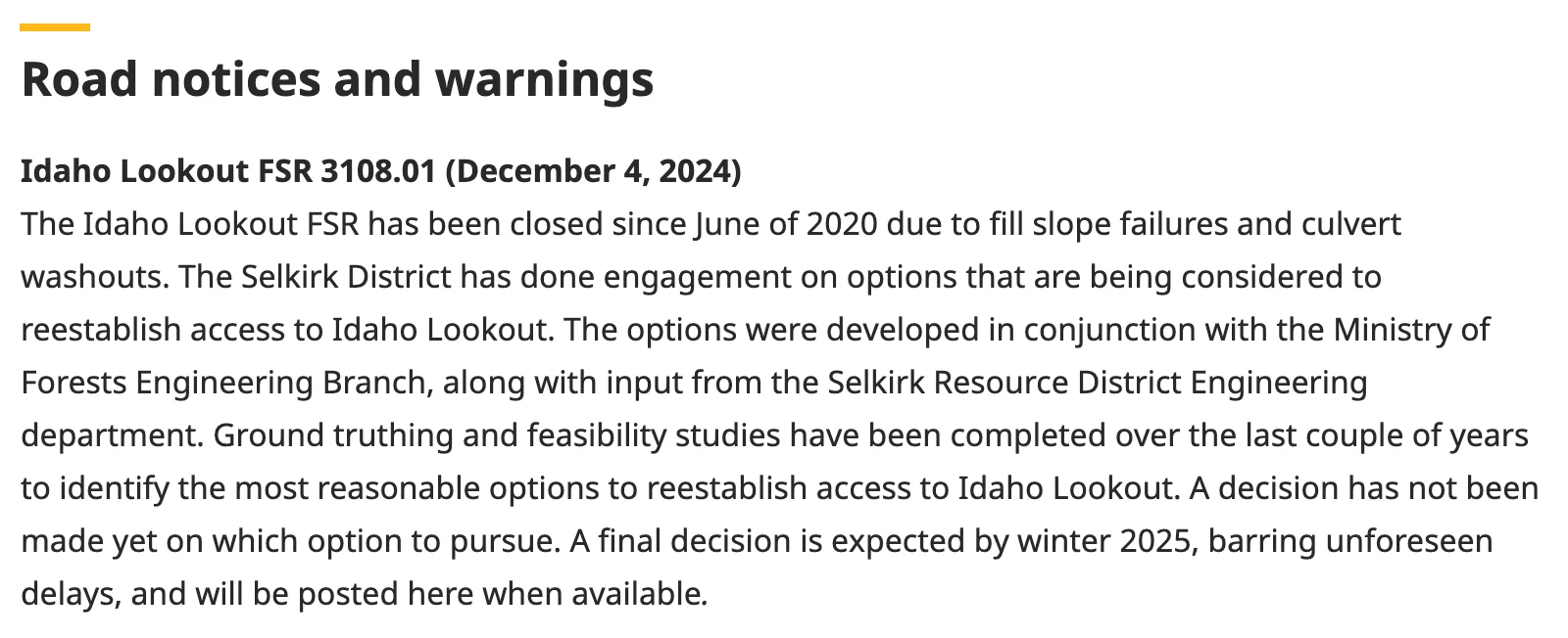
What it shows
The Province’s own page, four days after it was last edited. The entry is still headed “Idaho Lookout FSR 3108.01” — a Forest Service Road file number, on a Ministry of Forests district page. It still promises “a final decision… by winter 2025”, a deadline that expired before this page was touched. And the Ministry of Transportation is not mentioned anywhere on it.
Behind that page sits the register that actually governs. We queried the Province’s Forest Tenure Road Section Lines dataset on 22 September 2026 and pulled the record for this road exactly as the Crown holds it:
- Section name
- IDAHO LOOKOUT ROAD
- Map label
- 3108.01
- File type
- Forest Service Road
- Life cycle
- ACTIVE
- Client
- SELKIRK FOREST DISTRICT
- Length
- 11.754 km
- Retirement date
- none
Active. Forest Service Road. Held by a Ministry of Forests district. No retirement date. Rady Creek — Trout Lake–Rady Creek FSR 0321.02 — returns the same shape of record on the same day: an active Forest Service Road held by the same district.01
Two independent provincial systems, one a public web page and one a tenure register, both say the Ministry of Forests holds these roads today. Set against that, we have several residents relaying the same sentence from unnamed officials. The register is not a matter of opinion and neither is an Order in Council. Until one of them changes, the claim is not substantiated yet.
Section 03The Ministry has said it on the record, twice, and said nothing
The unverified doorstep version has a published cousin. Two ministry statements about Idaho Peak have reached print, and it is worth reading what each one actually commits the Crown to.
Ministry of Forests Reported by My Nelson Now, 23 January 2026 — paraphrase, no official named
The ministry “continue[s] to work with the Ministry of Transportation to evaluate the options.” None has yet been ruled out. No timeline.05
What it does not sayIt does not say Idaho Lookout has moved, and it does not say the Ministry of Transportation has assumed anything. Working with another ministry on options is not a transfer, and evaluating five options for thirteen months is not a decision. This is also a paraphrase — the outlet obtained a statement and summarised it, so we do not know the ministry’s exact words and cannot hold it to them.
“The government” Quoted directly by My Kootenay Now, 6 July 2026 — no official named
“The Ministry of Forests is still considering all options for the Idaho Peak forest service road, and field work will be conducted this season.”07
What it does sayIn July 2026, on the government’s own account, this is the Ministry of Forests’ road and the Ministry of Forests is the one deciding what happens to it. That is six months after the Transportation sentence appeared in print and roughly three months after residents say they were told the opposite at the road.
Put the two beside the spring accounts and the shape of the problem is clear. The public statements keep the file with Forests. The unverified doorstep answers move it to Transportation. Both cannot be right, and only one of them was said where anyone could write it down.
Section 04The explanation they will offer, and the map test it fails
There is an innocent reading available here and we should put it up before we knock it down, because it is the one the ministry will reach for.
Sandon does have a Ministry of Transportation connection, and the options package says so. It refers to “the current Ministry of Transportation and Infrastructure (MoTI) access to Sandon”, and Option 2 would tie a new road into that access about a hundred metres from Highway 31A. Three of the five published options tie into MoTI infrastructure in some way.03 So a district staffer, asked a fast question at the side of a road, could genuinely have meant the bit at the bottom near the highway is Transportation’s and been heard as the road is Transportation’s.
That reading survives exactly as long as it takes to open a map. The Province publishes the Digital Road Atlas, which classifies every road it knows about. We measured both corridors against it to a tolerance of fifteen metres.10
On the Idaho corridor, the only local-class public road anywhere near the alignment is 0.37 kilometres — three per cent — and it is two village streets in Sandon at the very bottom of the hill. The corridor itself, all 11.754 kilometres of it, is classed recreation. On the Rady corridor there is no local-class road at all: it is unclassified resource road from end to end, with the Silvercup Ridge Trail running above it.
Idaho Lookout
FSR 3108.01 · 11.754 km
- Corridor classed recreation in the Digital Road Atlas.
- Local-class public road on the corridor: 0.37 km — 3%.
- Those 0.37 km are two Sandon village streets at the very bottom.
- Tenure register: active Forest Service Road, Selkirk Forest District.
Trout Lake–Rady Creek
FSR 0321.02 · the road at tender
- Corridor is unclassified resource road, end to end.
- Local-class public road on the corridor: none.
- Silvercup Ridge Trail, an active recreation reserve since 1998, runs above it.
- Tenure register: active Forest Service Road, Selkirk Forest District.
What the map test shows
A road that had been transferred into the highway system would be classified as a highway, because that is what the Digital Road Atlas is for. Neither of these is. On Idaho the highway-class road runs out three per cent of the way up, and on Rady it never starts.
Neither claim can be explained by somebody misreading a map. There is nothing on either map to misread.
Section 05The mechanism: one Cabinet order, and nobody they are obliged to ask
Here is the machinery, because this is the part that decides whether a transfer would be good news or the worst outcome on the board.
Section 56(2) of the Transportation Act is the only lawful route. The Lieutenant Governor in Council — Cabinet — may order that a forest service road cease to be a forest service road for the purposes of the Forest Act and become a highway: an arterial highway if it lies inside a municipality, a rural highway anywhere else. Both Idaho Lookout and Rady Creek are outside any municipality, so the rural limb applies. The order requires the consent of both ministers, Transportation and Forests, and it is published.15
That is a high bar, and at first glance it looks like a protection. Read the next subsection and the protection evaporates.
Section 56(4) requires the minister to consult the council before making an order under section 56 that affects a road within a municipality.
Inside a municipality there is a council, that council must be consulted, and the consultation is a statutory duty with a body on the other end of it. On a rural forest road there is no council. There is nobody the minister is obliged to ask.15 The duty to consult in this statute is not a duty to consult the public. It is a duty to consult a municipal corporation, and it exists only where one exists.
Now recall what this district has already demonstrated it will do with a discretionary consultation. On Rady Creek, the Selkirk district took the deactivation of a public road to tender having never met the public — while its own tender package describes the project as “contentious and well known to the public” and budgets round-the-clock onsite security for the works.14 It wrote down that people would object, costed guards against them, and did not hold the meeting. And when a recreation trail designation was applied for over the same corridor, Recreation Sites and Trails BC refused it on jurisdictional grounds — the corridor is a forest service road, so the designation could not be made.13
That is the tactic already in evidence: decline to meet the public, and refuse the protective designation on the ground that the road is the wrong kind of thing. A transfer under section 56 does not correct either move. It moves the road one step further out of reach, to a statute where the duty to consult does not reach a rural road at all.
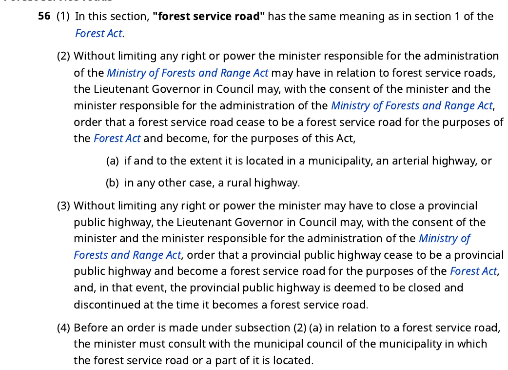
Read subsection (2) against subsection (4)
Subsection (2) is the whole mechanism: Cabinet may order a road to “cease to be a forest service road… and become… a rural highway”, with both ministers consenting. Then read subsection (4). The duty to consult exists only for a road inside a municipality. Idaho Lookout and Rady Creek are both outside one. On a rural forest road there is nobody the minister is obliged to ask.
Section 06This is not a handover. It is a demolition permit.
Getting a road into the highway system takes Cabinet, two ministers and a published order. Getting it out takes one minister and a notice.
Section 60 of the Transportation Act is the surplus highway power. Where the minister considers that a highway, or part of one, is “not considered necessary in the public interest”, the minister may publish a notice closing it. On the date stated in that notice the road ceases to be a highway, and the land is then available to be disposed of.15 One minister. One notice. No Cabinet, no second ministry, no hearing.
And while it is a highway, using it is a permission rather than a right. Section 62(1) is blunt: a person must not use or occupy a provincial public highway unless the person is authorized.15
Then look at what the Transportation Act does not contain. There is no recreation mandate in it — nothing that obliges the ministry to consider, preserve or restore recreational access. There is no duty to maintain; the powers to maintain, repair and rehabilitate are powers, not obligations. And there is no appeal anywhere in the Act against a closure decision. A corridor parked at Transportation is a corridor with no maintenance duty, no recreation mandate, no forest oversight and a one-signature disposal route.
That is the firebombing. Not the closure itself — the removal of every mechanism that could have stopped it. Compare what is live today, while these are still forest service roads: a recreation trail designation under section 56 of the Forest and Range Practices Act; a Licence of Occupation under section 39 of the Land Act once the corridor leaves the forest system into Crown land; a Forest Practices Board complaint, because the Board’s jurisdiction runs to forest practices on Crown land and a highway is not a forest practice.17 Every one of those runs through the Ministry of Forests holding the road. A transfer ends all of them at once.
The Licence of Occupation point deserves care, because it is the sharpest edge in this whole file. Section 39 of the Land Act operates over Crown land. Highway land is vested as highway. So the route Recreation Sites and Trails BC itself pointed to on Rady — apply for a Licence of Occupation once the corridor stops being a forest service road — only becomes available if the corridor lands in Crown land administration, and a transfer to Transportation forecloses it permanently.16 Nobody has to refuse an application. There is simply no application that can be made.
We should be honest about the other side of this, because there is one and it is not trivial.
What a transfer removes
All of it, at once
- Recreation trail designation under FRPA s.56 — the minister has nothing left to designate.
- Licence of Occupation under Land Act s.39 — highway land is not Crown land available for it.
- Forest Practices Board oversight — a highway is not a forest practice.
- Any duty to maintain, and any recreation mandate. Neither exists in the Transportation Act.
- Any appeal. There is none in the Act.
What genuinely improves
Say it plainly or nobody should believe the rest
- Section 60(3) requires four weeks’ notice before a closure takes effect. That is real, and it is better than the Forest Act, where a closure under s.121(9) bites on publication.
- Section 62(2) leaves an authorization door open: occupation and use can be permitted rather than simply barred.
- Transportation runs a network the public uses every day and is far more used to answering public pressure than a resource district is.
Four weeks’ notice is worth having. It is not worth trading a recreation designation, a Licence of Occupation, an oversight body and every existing protection to get. That is the exchange on offer, and it is not close.
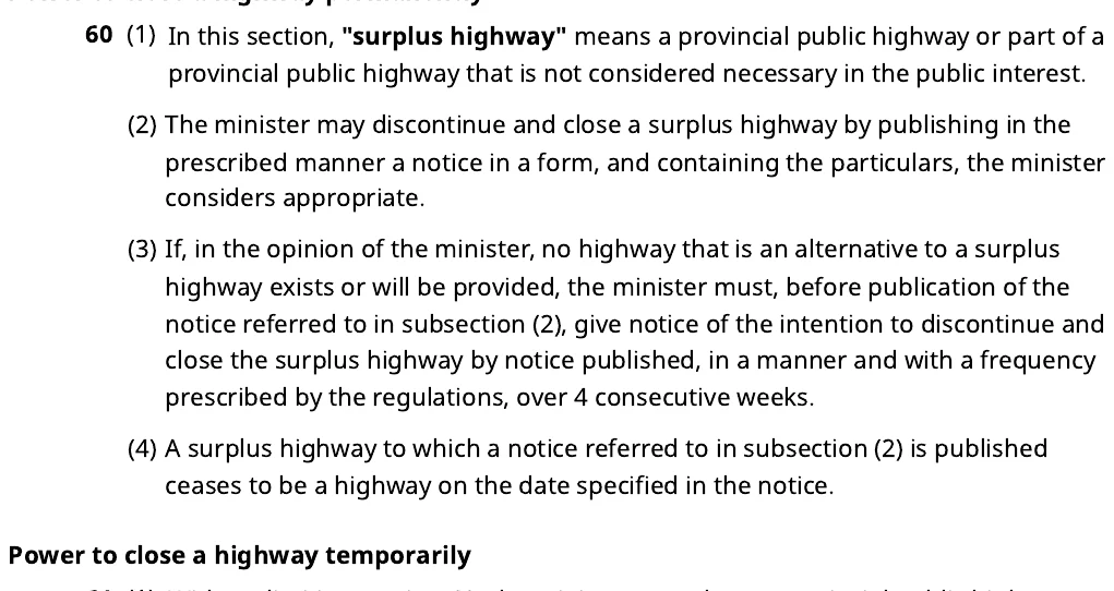
The way back out, and who holds it
A “surplus highway” is defined in (1) as one “not considered necessary in the public interest”. Under (2) the minister alone closes it by publishing a notice, and under (4) it stops being a highway on the date in that notice. The only brake is (3): four weeks’ notice where no alternative highway exists. A lightly used mountain road is exactly what that definition was drafted to describe.
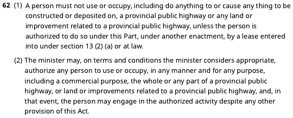
Using the road stops being a right
Subsection (1) is the sentence every user group should read twice: a person must not use or occupy a provincial public highway unless authorized. Subsection (2) is the door back in — the minister may authorize use “for any purpose”. Discretionary, unappealable permission, in place of a public resource road.
Section 07Follow the money, because that is the part nobody has costed
Every argument above is about power — who can close a road and who can be asked to stop. There is a second argument underneath it, and it is about money. Destroying a road is not free, and the Province publishes exactly what it pays.
We pulled the Ministry Contract Awards dataset from the BC Data Catalogue — every quarter from 2012 to March 2026, 15,108 awards — and filtered it to contracts whose scope is deactivation or decommissioning, excluding highway and paving work. The answer is 111 contracts and $20 million since 2012, spread across 65 named companies, the largest holding thirteen per cent of it. Thirteen of those 111 contracts name no vendor at all.19
What the Province pays to destroy forest roads
Every contract awarded since 2012 to deactivate a forest service road or pull out one of its crossings. Orange marks 2022 onward; the dashed line is Ravi Parmar’s election.
Source: Ministry Contract Awards, BC Data Catalogue, all quarters 2012 – March 2026. Highway, paving and resurfacing contracts excluded.
$19.97M
Awarded to deactivate forest service roads since 2012
30
Deactivation contracts in 2022 alone — six times the 2021 count
$3.5M
2024, the most expensive year on record
Two things jump out of that chart. 2022 is the break — thirty contracts in one year against five the year before, and the run rate never returns to where it was. And 2024 is the most expensive year the Province has ever had for this work, at $3.49 million. Whatever changed in 2022, it did not change back.
The gap that does not close
Now set that against how many roads are actually going. The mineral exploration industry compiled the Province’s own road-safety notices and counted 168 forest service roads closed or deactivated between 2024 and 2026, of which 85 are described as deactivation or decommissioning.20 Against that, the Province awarded 23 deactivation contracts in 2024 and 2025 combined, worth $5.4 million.
Roads closed against roads paid for
Closures counted from the Province’s road-safety notices, contracts counted from its own award record.
Closure counts: industry compilation of provincial Resource Road Safety Information notices, 2024–2026. Contract counts: Ministry Contract Awards, BC Data Catalogue.
Roads are being closed roughly four times faster than anyone is paid to close them. That is not a contradiction and it is not fraud. It is the mechanism. Most of these roads are not destroyed by machines at all. They fail, they are barricaded, no repair is funded, and they quietly stop being usable. The paperwork records a closure. Nobody is paid anything. Idaho Lookout has been in that column for six years.
What this is really about
The Province is not short of ways to close a road. It is short of money to do it properly, and the record above shows what doing it properly costs: a four-kilometre job like Rady sits in a band that runs from roughly $80,000 to $500,000, and the district has to find that money inside a budget that has not funded maintenance on this road in more than a decade.
A transfer solves that problem in a way that nothing else does. It does not just move a road. It moves the liability. On the far side of section 56(2) the corridor stops being a forest road with a maintenance history, a prescription, a recreation reserve above it and a Forest Practices Board that can be asked about it. It becomes a rural highway held by another ministry — one with no recreation mandate, no maintenance duty, no appeal process, and a closure test that asks only whether a road is “necessary in the public interest.” A lightly used mountain road fails that test on its face.
And the consultation burden goes with it. Read section 56(4) once more: the duty to consult a municipal council exists only for a road inside a municipality. Rady Creek and Idaho Lookout are both outside one. Nobody has to be asked before the order is made, and once the corridor is a surplus highway, one minister closes it by publishing a notice.
Nobody is going to write this down, and they do not have to. The spending record, the closure count and the statute say it between them. A ministry that cannot afford to destroy a road properly, handing it to a ministry that can destroy it cheaply and without asking anyone, is not transferring responsibility. It is firebombing the asset on the way out.
If we have that wrong, the Ministry can say so in two sentences: name the budget line for the Rady deactivation, and confirm no transfer has been proposed for either road. We have asked. We will publish whatever comes back, including nothing.
Section 08Highway status is worse for the machines people actually ride
There is a second reason to be suspicious of anyone selling a Transportation transfer as good news, and it has nothing to do with statutes. It has to do with who uses these roads.
On a maintained public highway, an off-road vehicle is a motor vehicle on a highway. That means registration, insurance, a helmet and a valid driver’s licence — and a large share of the machines that use these corridors are not road-legal at all and cannot be made road-legal.18 Quads, side-by-sides, dirt bikes and snowmobiles are exactly the traffic these roads carry, and exactly the traffic that highway status regulates hardest. A forest service road is a place those machines belong. A rural highway is a place they mostly do not.
So the transfer is not even an upgrade in the shallow, practical sense. For hikers it changes little. For everyone riding something with knobby tyres it is a downgrade written into the licensing law, before anybody gets to the question of whether the road survives at all.
One part of that law is worth knowing, because it turns a sympathetic council into a partner rather than a letter-writer. A municipality may pass a bylaw permitting off-road vehicles on roads inside its boundaries.18 Silverton, New Denver and the other Slocan and Lardeau communities have that power over their own streets. They do not have it over a rural forest road outside their boundaries — which is the same boundary line that decides, under section 56(4), whether anybody has to consult them at all. Local government is on the wrong side of that line by default, and the only way it gets on the right side is by being brought in early and in writing.
Section 09Rady is next, and after Rady it is arithmetic
Idaho Lookout and Trout Lake–Rady Creek are the same district, the same shape of problem and the same answer given at the roadside. The difference is that Rady is further down the track: the closure is already at tender, and the contract to destroy the road is live.14
The two files also share a contractor footprint worth naming, because it shows how ordinary this machinery is. Cooper Creek Cedar Ltd. held road permit R22242 on the Idaho system — Idaho 3000, Idaho Mainline Extension and Idaho 1000, retired in December 2023 — and holds permit R07745 at Trout Lake, with thirty road sections, most of them still active. The same company ran the 2020 deactivation referral on Rady. It does not hold the Rady forest service road itself; that is held by the district.12 Nothing improper follows from any of that. It is simply the same handful of instruments, held by the same handful of parties, moving across both corridors.
And both corridors are the access to a recreation asset the Crown itself created and still recognises. The Idaho Peak Hiking Trail is an active Recreation Trail Reserve, file REC202754. The Silvercup Ridge Trail above Rady is an active reserve established in 1998.11 Destroying the road strands the trail. The Province is on both sides of that transaction.
Which is why the pathway matters far beyond these two roads. Section 56 does not mention Idaho or Rady. It applies to a forest service road, any of them. There are tens of thousands of kilometres of forest service road in British Columbia, and the entire public protection regime over them — recreation designation, Licence of Occupation, Forest Practices Board oversight — depends on the Ministry of Forests continuing to hold them. The instrument that moves a road out of that regime has been on the books for years and has never once been used. If it is used here, it will not be used here only.
Section 10What to put in writing, now
Everything in this piece is checkable, and most of it is checkable by anyone with an email account. If you have been told one of these roads belongs to Transportation now, do not argue about it. Ask for the instrument. There is only one, and it either exists or it does not.
- Ask for the Order in Council number and the date. Put it to whoever told you, in writing, in one sentence: please provide the Order in Council number and date by which this road ceased to be a forest service road under section 56 of the Transportation Act. There is no informal or administrative way to do this, so there is no other answer available. If none comes back, you have your answer and so does everyone else.
- Check the register yourself. The Forest Tenure Road Section Lines layer is published openly by the Province. Search the road’s map label — 3108.01 for Idaho Lookout, 0321.02 for Rady — and read the file type, the life cycle status and the client name. Today both say Forest Service Road, ACTIVE, Selkirk Forest District.01 If that changes, it changes in public.
- Put the Licence of Occupation question to Water, Land and Resource Stewardship, with a date on it. The ministry has pointed people toward a Licence of Occupation under Land Act section 39 as the route after closure. The question worth asking WLRS in writing is narrow and answerable: would an application over this corridor be accepted, and on what date does it become possible? A written answer either confirms that route or exposes it.16
- Use the Forest Practices Board while it still has jurisdiction. The Board can examine compliance with the Forest and Range Practices Act and the protection of recreational resources on Crown land. It cannot examine a highway. That jurisdiction exists today and ends the moment a road leaves the forest system.17
- Bring your council in. Silverton, New Denver, Kaslo and the regional district are not bystanders here. Under section 56(4) a council must be consulted about a road inside its boundaries and need not be consulted about one outside them, and a municipality can permit off-road vehicles on its own roads and nowhere else. A council that writes early is a party to this file. A council that waits is a spectator.15
These roads are still forest service roads today, and that is the only reason any of this can still be stopped. The sentence is already circulating — said to people at the roadside, in a district that would not meet the public on Rady — and the route it points at would strip every protection these corridors have and replace them with one minister’s signature. The Ministry has spent $20 million taking public roads apart and it is closing them four times faster than it pays anyone to do it. A ministry in that position does not need a conspiracy to reach for a free exit. It needs an opportunity, and the legislation is holding one open. If that is the plan, make somebody put their name on it. Cabinet orders are published. So far there is nothing to publish — and that is the only advantage the public has left on these two roads.
Share this story
Six images carrying this story on their own — the record, the mechanism and what it costs. Made to be posted.


Slide 1 of 6
Suggested caption
Idaho Lookout forest service road has been shut for six years with no repair date and no decision. This spring the barricade came down with the damage untouched, and people asking what that meant were told the road is the Ministry of Transportation's now.
That part is second-hand and we cannot substantiate it yet. What is on the record is the Ministry of Forests telling the press in January 2026 that it continues to “work with the Ministry of Transportation to evaluate the options” — on a forest road whose published options include permanent closure.
So we read every Order in Council made in British Columbia since 2022. All 3,137. Not one moves a road out of the forest system, and both roads are still listed as active Forest Service Roads today. That is not a defence, it is a deadline: every forest-law remedy is live now and none survives the day an order is signed.
The question is why this Ministry would want one. Since 2012 it has spent $20 million deactivating roads it had already stopped maintaining, and it is closing them roughly four times faster than it pays anyone to do it. A transfer takes that cost off the books — along with the recreation designation, the Licence of Occupation, the Forest Practices Board and the duty to consult anybody outside a municipality.
And highway status is worse for the machines these corridors carry, not better. An ATV on a maintained highway needs registration, insurance, a helmet and a valid driver's licence, and many machines are not road-legal at any price.
backcountry.cx/editorials/handed-over-to-be-erased/
#BCpoli #PublicLand #RadyCreek #IdahoPeak #Kootenays
Sources
- ↩↩↩↩Forest Tenure Road Section Lines — BC Data Catalogue. Province of British Columbia, BC Geographic Warehouse, Forest Tenure Road Section Lines (WHSE_FOREST_TENURE.FTEN_ROAD_SECTION_LINES_SVW), published on the BC Data Catalogue. Queried 22 September 2026. Idaho Lookout record as returned: ROAD_SECTION_NAME IDAHO LOOKOUT ROAD; MAP_LABEL 3108.01; FILE_TYPE_DESCRIPTION Forest Service Road; LIFE_CYCLE_STATUS_CODE ACTIVE; CLIENT_NAME SELKIRK FOREST DISTRICT; ROAD_SECTION_LENGTH 11.754 km; RETIREMENT_DATE none. The Trout Lake–Rady Creek record (MAP_LABEL 0321 02) returns the same file type, the same ACTIVE life cycle status, the same client and no retirement date on the same date. https://catalogue.data.gov.bc.ca/dataset/forest-tenure-road-section-lines
- ↩↩↩Idaho Lookout FSR 3108.01 — the district’s road safety entry. Province of British Columbia, Selkirk Natural Resource District road safety information. The entry is headed “Idaho Lookout FSR 3108.01” and carries the June 2020 notice: “Road closed at 1.5 km due to fill slope failures and culvert washout. Has been barricaded. No planned repair date.” As updated 18 September 2026 the same entry reads “A decision has not been made yet… A final decision is expected by winter 2025.” The Ministry of Transportation and Infrastructure is not named anywhere on the page. The page also carries the Trout Lake Rady-Creek FSR 0321.02 deactivation entry. https://www2.gov.bc.ca/gov/content/industry/natural-resource-use/resource-roads/local-road-safety-information/selkirk-natural-resource-district-road-safety-information
- ↩↩Castanet Nelson on the Idaho Lookout options. “Five options presented for restoring access to Idaho Lookout”, Castanet Nelson, 17 January 2025, reporting the Ministry of Forests’ published options summary; the same options were reported in the Valley Voice. Option 4 “would require private land acquisition, since the current road trespasses on private property”; Option 5 is “the permanent closure of the FSR, requiring full road deactivation”, after which “Idaho Lookout would no longer be accessible.” Three of the five options build a new bridge and up to 10 km of new road. The options summary refers to “the current Ministry of Transportation and Infrastructure (MoTI) access to Sandon”; Option 2 would connect a new road to that access approximately 100 m from Highway 31A, and three of the five options tie into MoTI infrastructure. https://www.castanet.net/news/Nelson/528189/Five-options-presented-for-restoring-access-to-Idaho-Lookout
- ↩Sandon Historical Society to its members. Sandon Historical Society, “Idaho Peak FSR — looking for public feedback”. The Society told members that volunteers had kept the trails open on foot since the closure and that “options 2 and 3 would take out much of the existing trails H-Road and Choices.” https://www.sandonmuseum.com/post/idaho-peak-fsr-looking-for-public-feedback
- ↩↩My Nelson Now, 23 January 2026. “Still no decision on new route to Idaho Peak”, My Nelson Now, 23 January 2026. The outlet reports that the ministry “continue[s] to work with the Ministry of Transportation to evaluate the options” and that none has yet been ruled out, with no timeline given. This is the journalist’s paraphrase of a statement the outlet obtained, not a direct quotation, and no official is named in the story. We have not seen the underlying statement. https://www.mynelsonnow.com/76769/news/community/still-no-decision-on-new-route-to-idaho-peak/
- ↩My Nelson Now, 4 February 2026. “Restore existing Idaho Peak access road, resident says”, My Nelson Now, 4 February 2026. Don Broughton, Silverton village councillor and former Idaho Peak shuttle operator, called for the existing road to be restored, said the public cannot assess the options without cost estimates, reported that “some people worry the consultation process will lead to the permanent closure of public access”, and asked: “If we have to get a group to maintain it, at least give us that chance.” https://www.mynelsonnow.com/76969/news/business/tourism/restore-existing-idaho-peak-access-road-resident-says/
- ↩↩My Kootenay Now, 6 July 2026. “Idaho Peak access to remain closed this summer”, My Kootenay Now, 6 July 2026: “The Ministry of Forests is still considering all options for the Idaho Peak forest service road, and field work will be conducted this season.” A direct quotation, attributed in the story only to “the government”; no official is named. https://www.mykootenaynow.com/74928/news/business/tourism/idaho-peak-access-to-remain-closed-this-summer/
- ↩↩Second-hand accounts, two roads in the Selkirk district. These accounts have not been independently confirmed. Accounts reaching the Coalition in the week to 22 September 2026 from residents of the Selkirk district, concerning two different roads. The accounts are that in spring 2026 the barricade and road-closed sign on the Idaho Lookout FSR were removed with the damage unrepaired, and that people who asked were told the road is a Ministry of Transportation responsibility and no longer under the Ministry of Forests. These are second-hand. There is no document and no named official behind any of them, and we cannot substantiate the jurisdiction claim yet. They are reported here because they are consistent across multiple independent sources and because they are the reason we searched the Order in Council record. They are not evidence that a transfer occurred.
- ↩The Order in Council sweep — 3,137 orders, 2022 to 2026. Province of British Columbia, Orders in Council, current and archived collections. Every Order in Council made between 2022 and 2026 was downloaded and text-searched: 409 in 2026, 602 in 2025, 694 in 2024, 734 in 2023 and 698 in 2022 — 3,137 orders in total. Searched for “forest service road”, “Rady” and “Trout Lake”. The four raw hits are a violation-ticket regulation, a bring-into-force order, an omnibus regulation amendment and an appointments order naming a person called Brady. No order in that period transfers any road out of the forest system. Method validated in both directions: extraction confirmed working on a control order, and a genuine historic forest-road order returns hits on the exact phrase, so the sweep would have found one had it existed. The sweep proves no order was made; it cannot see internal deliberation. https://www.bclaws.gov.bc.ca/civix/content/oic/
- ↩Digital Road Atlas — BC Data Catalogue. Province of British Columbia, BC Geographic Warehouse, Digital Road Atlas (WHSE_BASEMAPPING.DRA_DGTL_ROAD_ATLAS_MPAR_SP), published on the BC Data Catalogue. Segments were matched to each corridor to a tolerance of 15 m. Idaho corridor: the only local-class public road is 0.37 km, three per cent of the alignment, comprising two village streets in Sandon at the bottom of the corridor; the corridor itself is classed recreation. Rady corridor: no local-class road at any point; segments return unclassified resource road, with the Silvercup Ridge Trail above. Neither corridor carries a highway class, a route number, or an arterial or rural highway designation. https://catalogue.data.gov.bc.ca/dataset/digital-road-atlas-dra-master-partially-attributed-roads
- ↩Forest Tenure Recreation Lines. Province of British Columbia, BC Geographic Warehouse, Forest Tenure Recreation Lines (WHSE_FOREST_TENURE.FTEN_RECREATION_LINES_SVW). Idaho Peak Hiking Trail: Recreation Trail Reserve, file REC202754, status active. Silvercup Ridge Trail: Recreation Trail Reserve, file REC2372, status active, established 31 July 1998; one of its segments falls within the Rady corridor’s bounding box. https://catalogue.data.gov.bc.ca/dataset/forest-tenure-recreation-lines
- ↩Cooper Creek Cedar road permits R22242 and R07745. Province of British Columbia, forest tenure road permit records. Cooper Creek Cedar Ltd. held road permit R22242 covering Idaho 3000, Idaho Mainline Extension and Idaho 1000, retired December 2023, and holds R07745 at Trout Lake, 30 road sections, most still active. The company ran the 2020 deactivation referral on the Trout Lake–Rady Creek corridor. It does not hold the Rady forest service road itself, which is held by the Selkirk Natural Resource District (see source 1). https://catalogue.data.gov.bc.ca/dataset/forest-tenure-road-section-lines
- ↩Recreation trail designation refused, project ID 976595. Recreation Sites and Trails BC, decision of 19 August 2026, project ID 976595: an application to designate the Trout Lake–Rady Creek corridor as a recreation trail was refused on jurisdictional grounds while the corridor remains a forest service road, with a Licence of Occupation under Land Act section 39 identified as the route available after the corridor ceases to be an FSR. Decision held on file.
- ↩↩BC Bid opportunity 233877 — the Rady Creek tender. Province of British Columbia, Ministry of Forests, Invitation to Tender EN27DSE008 — Trout Lake Rady-Cr FSR 0321.02 Road Deactivation, BC Bid opportunity 233877, tender package: “This deactivation project is contentious and well known to the public. The Ministry of Forests will provide 24/7 onsite security services for the entire duration of deactivation operations.” The absence of any consultation meeting on this file between 2021 and the tender is set out, with its sources, in The Selkirk district office. Held on file. https://www.bcbid.gov.bc.ca/page.aspx/en/bpm/process_manage_extranet/233877
- ↩↩↩↩↩Transportation Act — sections 56, 60 and 62. Transportation Act, SBC 2004 c.44, BC Laws. Section 56(1)–(2): the Lieutenant Governor in Council may order that a forest service road cease to be a forest service road for the purposes of the Forest Act and become an arterial highway (within a municipality) or a rural highway (elsewhere), with the consent of both ministers. Section 56(4): the consultation requirement with a municipal council applies to a road within a municipality. Section 60(1)–(4): the minister may, by published notice, declare a highway or part of one surplus where it is not considered necessary in the public interest; subsection (3) requires four weeks’ notice; the road ceases to be a highway on the date stated in the notice. Section 62(1): a person must not use or occupy a provincial public highway unless authorized; section 62(2) provides for that authorization. The Act contains no recreation mandate, no duty to maintain and no appeal against a closure decision. https://www.bclaws.gov.bc.ca/civix/document/id/complete/statreg/04044_01
- ↩↩Land Act — section 39. Land Act, RSBC 1996 c.245, BC Laws, section 39: licences to occupy Crown land. Read with Transportation Act sections 57 and 58, which vest the soil and freehold of a provincial public highway in the government and place the government’s title with the BC Transportation Financing Authority, a corridor that has become highway is not Crown land available for a section 39 licence. https://www.bclaws.gov.bc.ca/civix/document/id/complete/statreg/96245_01
- ↩↩Forest Act section 121(9); Forest and Range Practices Act section 56. Forest Act, RSBC 1996 c.157, BC Laws, section 121(9): the minister may, by notice, discontinue and close a forest service road or part of one, effective on publication. Forest and Range Practices Act, SBC 2002 c.69, BC Laws, section 56: recreation trail and recreation site designation by the minister over Crown land. The Forest Practices Board’s mandate runs to forest and range practices under FRPA and the Wildfire Act on Crown land; a provincial public highway is outside it. https://www.bclaws.gov.bc.ca/civix/document/id/complete/statreg/96157_08
- ↩↩Off-Road Vehicle Act and Motor Vehicle Act — highway use requirements. Off-Road Vehicle Act, SBC 2014 c.5, BC Laws, and Motor Vehicle Act, RSBC 1996 c.318, BC Laws. Operating a motor vehicle on a highway in British Columbia engages the Motor Vehicle Act requirements for registration, insurance and a valid driver’s licence, together with the helmet requirement; many off-road machines do not meet the equipment standards required to be registered for highway use. A municipality may pass a bylaw permitting off-road vehicles on roads within its boundaries; that power does not reach a rural road outside them. Readers should confirm the current requirements for their own machine before relying on this summary. https://www.bclaws.gov.bc.ca/civix/document/id/complete/statreg/14005
- ↩Ministry Contract Awards, 2012 to March 2026. Province of British Columbia, Ministry Contract Awards, BC Data Catalogue, all quarterly releases 2012 to March 2026 — 15,108 award records. Filtered to awards whose Title contains “deactivat” or “decommission”, with highway, asphalt, sealcoat, hot-in-place and pavement-marking contracts excluded as Ministry of Transportation work: 111 contracts, $19,973,741, 66 distinct successful vendors. Year-by-year counts and values are as plotted. The dataset publishes a Successful Vendor and Award Total per contract and lags roughly two quarters, so the Rady contract will not appear in it until well after the work is done. catalogue.data.gov.bc.ca https://catalogue.data.gov.bc.ca/dataset/ministry-contract-awards-province-of-british-columbia
- ↩168 roads listed, 85 deactivated or decommissioned. Closure counts compiled from the Province’s Resource Road Safety Information notices for 2024–2026 and tabulated by the mineral exploration industry: 168 forest service roads listed, of which 85 carry a stated reason of deactivation or decommissioning. Regional split: Thompson Rivers 84, Chilliwack 23, Prince George 17, Selkirk 12, with the remainder spread across nine other districts. We have verified the arithmetic and the regional totals against the tabulation; we have not independently re-checked each of the 168 notices against the provincial portal. https://www2.gov.bc.ca/gov/content/industry/natural-resource-use/resource-roads/local-road-safety-information
Correction · 23 September 2026
We changed the spending figures in this article
As published on 22 September, this article said the Ministry of Forests had spent $20.7 million across 121 contracts and 77 named companies. Those figures came from a filter that matched the word “decommissioning” — which is also what the Province calls retiring a water well, a dam or a marina. Eighteen contracts worth $3,065,876 had nothing to do with forest roads.
We rebuilt the dataset around roads and the crossings that make them passable, merged three spellings of one firm, and removed one award the Province published twice. The figures in this article now read $20 million, 111 contracts and 65 named companies. The argument is unchanged: the spending is real, the pace more than doubles from 2022, and 2024 is still the most expensive year on record.